
Page 146 - (DK Eyewitness) Travel Guide - Southwest USA & National Parks
P. 146
144 SOUTHERN UT AH SOUTHERN UT AH 145
1 Arches National Park VISITORS’ CHECKLIST
Arches National Park contains the highest number Practical Information
of natural stone arches found anywhere in the Road map: 2C. n Arches Visitor
world. More than 80 of these natural wonders have Center (435) 719-2299. Open
Apr–Oct: 7am–7pm daily;
formed over millions of years. The park “floats” on a Nov–Mar: 9am–4pm daily.
salt bed, which once liquefied under the pressure & 7 campground, Park Ave.
exerted by the rock above it. About 300 million Viewpoint, Delicate Arch
years ago, this salt layer bulged upward, cracking Viewpoint Trail, and Balanced
Rock Trail. 8 =
the sandstone above. Over time the cracks eroded, ∑ nps.gov/arch
leaving long “fins” of rock. As these fins in turn Devil’s Garden Delicate Arch
The most celebrated of all the
eroded, the hard overhead rock formed arches, This area contains several of the park’s finest arches here, and a state symbol,
which range today from the solid-looking Turret arches, including Landscape Arch, a slender Delicate Arch appears on many Arches are formed through a
Arch to the graceful Delicate and Landscape arches. curve of sandstone more than 300 ft (91 m) Utah license plates. It is reached process that takes millions of
long, thought to be the longest natural arch by a moderate 45-minute walk years; today’s arches continue Western-style, timber-clad gift store on
in the world. over sandstone. to slowly erode and will Main Street, Moab
event ually collapse.
2 Moab
Road map 2C. * 5,300. n Main and
Center sts. (435) 259-8825. Open mid-
Mar–Oct: 8am–7pm Mon–Sat, 9am–
6pm Sun; Nov–mid-Mar: 9am–5pm
daily. ∑ discovermoab.com
A town of dramatic ups and
downs, Moab is once again
growing. It is lively and has
good facilities. In 1952 a local
Sunset watch at Delicate Arch prospector discovered the first
A natural amphitheater surrounds the arch, of several major uranium dep-
creating seating from which vistas of the La Sal osits outside town. Overnight,
Mountains are framed. Moab became one of the
wealthiest communities in
America. When the uranium
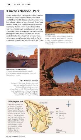
The Windows Section market declined in the 1970s,
In the park’s Windows Section, a one-mile Balanced Rock the town was saved by tourism
loop trail leads to Turret Arch, then the This precariously balanced and its proximity to Arches and
North and South Windows arches, boulder atop a sandstone spire is Canyonlands national parks.
situated side by side. With excellent viewing one of the park’s landmarks. Good Today, Moab is one of the top
spots available, many visitors photograph views are available from the trail destinations for lovers of the
North and South arches framed by the as well as the scenic road route. outdoors. Mountain bikers
sandstone Turner Arch, as seen here. come here to experience the
famous Slick Rock Trail. They
also come for the challenging
Exploring the Park ride to Moab Rim, a strenuous
Landscape Arch journey that entails a trek of
The park’s highlights can about 10 miles (16 km). There is
be seen from the many also a vast choice of hiking and
viewpoints dotted along KeyKey 4WD routes taking in some of
the scenic drive. The drive this region’s fabulous landscapes.
starts at the visitor center at Delicate HighwayHighway Matheson Wetlands
the park’s south end, just off Arch Unpaved roadUnpaved road Preserve off Kane Creek Blvd
Hwy 191. Several easy trails 4WD only4WD only has 2 miles (3 km) of hiking
start from parking lots at the Balanced Hiking trailHiking trail trails along a riverside wetland
road’s viewpoints. The loop Rock that is home to birds and
at Balanced Rock is a short
and easy trail suitable for Windows wildlife. Moab is also a center
children, while Delicate Section for whitewater rafting on the
Arch Viewpoint Trail has Colorado River.
disabled access. The Park Avenue and the Courthouse Towers
Windows loop is 0 km 5 The large, rock monoliths known as Courthouse Towers bear an O Matheson Wetlands Preserve
suitable for families. uncanny resemblance to city skyscrapers. They can be seen from Park Off Kane Creek Blvd. Tel (435) 259-
moab 0 miles 5
Avenue, an easy, short trail. 4629. Open dawn–dusk daily. &
For keys to symbols see back flap For hotels and restaurants see pp240–41 and pp254–6
144-145_EW_SW_USA.indd 144 28/11/17 12:40 PM 144-145_EW_SW_USA.indd 145 28/11/17 12:40 PM
Eyewitness Travel LAYERS PRINTED:
Catalogue template “UK” LAYER
(Source v2.6)
Date 12th July 2013
Size 125mm x 217mm