
Page 148 - (DK Eyewitness) Travel Guide - Southwest USA & National Parks
P. 148
146 SOUTHERN UT AH SOUTHERN UT AH 147
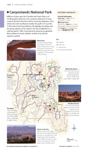
3 Canyonlands National Park VISITORS’ CHECKLIST
Millions of years ago, the Colorado and Green Rivers cut Practical Information
winding paths deep into rock, creating a labyrinth of rocky Road map C2. Tel (435) 719-
canyons that form the heart of this stunning wilderness. At its 2313; (435) 719-2100.
∑ nps.gov/cany
center, the rivers’ confluence divides the park’s 527 sq miles Visitor center: Open 8am–4:30pm
(1,365 sq km) into three districts: the Needles, the Maze, and daily (longer in spring, summer, &
the grassy plateau of the Island in the Sky. Established as a fall). Closed Jan 1, Thanksgiving,
national park in 1964, Canyonlands is growing in popularity. Dec 25. & 7 8 =
Most wilderness travel, whether on foot or by vehicle,
requires a permit.
Key
Mesa Arch
An easy and rewarding Highway
500-yard (0.5-km) trail 4WD only
leads to Mesa Arch, a long, Hiking route
low curve of stone that
perfectly frames the snow- National Park boundary
capped La Sal Mountains
in the distance.
The stunning desert-scape visible from the Green River Overlook in Canyonlands National Park
4 Dead Horse Point sight of the Colorado River far E John Wesley Powell River
State Park below. The Park also features History Museum
White Rim Road is a several short hiking trails that 1765 E. Main St. Tel (435) 564- 3427.
100-mile (160-km) trail Road map C1. n State Route 313 follow the cliff edge, offering Open Apr–Oct: 9am–7pm Mon–Sat,
J
accessed via the (435) 259-2614. Open 6am–10pm variations on the truly amazing noon–5pm Sun; Nov–Mar: 9am–5pm
Horseshoe Upheaval Dome Overlook J exhilarating Shafer daily. Visitor center Open Apr–Oct: view. The drama of this place Tue–Sat. Closed public hols. & 8
∑ johnwesleypowell.com
Canyon J Road, a 4WD drive 8am–6pm daily; Nov–Mar: 8am–5pm has not been lost on Hollywood
contains track down a steep cliff. daily. & 7 ∑ stateparks.utah.gov (see pp34–5). Famous as the spot
6,000-year-old where Thelma and Louise drove
petroglyphs, Grand Colorado River The high mesa of Dead Horse off the edge in the 1991 film of
said to be the View Point Point lies just outside the entry the same name, in 2000 these
oldest in Green River J to the Island in the Sky of cliffs were scaled by Tom Cruise
Overlook
existence. J Canyonlands National Park. in Mission Impossible: 2.
Unforgettable views of the
Colorado River and the maze of
Maze deep canyons are a highpoint 5 Green River
Overlook here. Legend has it that this park Road map C1. * 1,000. n 885
owes its name to the fact that it E. Main St (435) 564-3427.
J
was once used as a natural corral Open Apr–Oct: 8am–7pm;
Needles District for wild mustangs. A group of Nov–Mar: 9am–5pm daily.
J
The most interesting horses not chosen for taming Eroded rock formations of Goblin Valley
features in this remote were once left in this dry site, Located in a broad, bowl- State Park
The Maze district are the
canyons, where hundreds of red rock eventually dying of thirst within shaped valley, the town grew 6 Goblin Valley
outlaw Butch spires, or needles, for around a ford of the wild Green
Cassidy hid out which it was named. River in the 19th and early 20th State Park
in the late 1800s, centuries. Primarily a service
offer a challenge town, it is also a launching Road map C1. Tel (435) 275-4584.
to skilled hikers. spot for those braving the Open 6am–10pm daily. &
whitewater of the Green ∑ stateparks.utah.gov
and Colorado Rivers.
John Wesley Powell (see p29) The “Goblins” of Goblin Valley
Island in the Sky began his intrepid exploration State Park are a group of
Easy access by car makes of the Colorado River and mushroom-shaped rocks, or
this the most visited district of Grand Canyon from here in hoodoos, intricately carved by
the park. A popular stop is the 1871. The John Wesley Powell erosion. Visitors are free to wander
Grand View Point Overlook, River History Museum has among these rocks, which are
which offers panoramic views 0 km 5 20,000 sq ft (1,860 sq m) of up to 10 ft (3 m) in height. Two
of the rocky canyons of the 0 miles 5 Dramatic cliffs as seen from Dead Horse displays tracing the history paved and several unpaved trails
Green and Colorado rivers. Point State Park of the area’s exploration. lead down to the valley floor.
For hotels and restaurants see pp240–41 and pp254–6 For keys to symbols see back flap The great red dome of the Golden Cathedral, Grand Staircase–Escalante National Monument
146-147_EW_SW_USA.indd 146 28/11/17 12:41 PM 146-147_EW_SW_USA.indd 147 28/11/17 12:41 PM