
Page 78 - (DK Eyewitness) Travel Guide - Southwest USA & National Parks
P. 78
76 ariz ona nor thern ariz ona 77
sinkhole every minute, an u Meteor Crater
inexhaustible supply that has Road map C3. Off Hwy 40 exit 233.
long been used to irrigate the Tel (800) 289-5898. Open Jun–Aug:
surrounding land. A narrow trail 7am–7pm daily; Sep–May: 8am–5pm
leads around the rim, before daily. Closed Dec 25. &
twisting its way down to the ∑ meteorcrater.com
water’s edge.
The Barringer Meteor Crater, a
meteorite impact crater, was
r Jerome formed nearly 50,000 years
ago. The crater is 550 ft (167 m)
Road map B4. * 500. n 310
Hull Ave., Jerome (928) 634-2900. deep and 2.4 miles (4 km) in
7 partial. ∑ jeromechamber.com circumference, and so closely
resembles a moon crater that
Approached from the east NASA astronauts trained here in
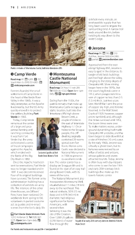
Pueblo remains of Montezuma Castle, built into limestone cliffs along Highway 89A, Jerome is the 1960s. Guided rim tours are
easy to spot in the distance, its available, and the visitor center
w Camp Verde e Montezuma tangle of old brick buildings tells the story of the crater
Road map B4. * 6,000. n 435 Castle National perched high above the valley, through exhibits and a film.
South Main St. (928) 554-0851. Monument clinging to the steep slopes of
∑ visitcampverde.com Cleopatra Hill. Silver mining i Petrified Forest
Road map C4. Hwy I-17 exit 289. began here in the 1870s, but
Farmers founded the small Tel (928) 567-3322. Open 8am–5pm the town’s big break came in National Park
settlement of Camp Verde in daily. & ∑ nps.gov/moca 1912, when prospectors hit a Road map D3. Off Hwy I-40. Tel (928)
the heart of the Verde River vein of copper no less than 5 ft 524-6228. Open hours vary (about
Valley in the 1860s. It was a Dating from the 1100s, the (1.5 m) thick. Just two years 7am–8pm in mid-summer and
risky enterprise, as the Apache pueblo remains that make up later, World War I sent the price 8am–5pm in mid-winter). Closed
lived nearby, but the US Army Montezuma Castle occupy an of copper sky high, and Jerome Dec 25. & ∑ nps.gov/pefo
quickly moved in to protect idyllic location, built into the boomed. In the Wall Street
the settlers, building Fort limestone cliffs high above Crash of 1929, however, copper The ford across picturesque Oak Creek at Red Rock Crossing, Sedona This national park is one of
Verde in 1865. Beaver Creek, a prices tumbled, and, although Arizona’s most unusual
Today, Camp Verde couple of miles to the mines survived until 1953, t Tuzigoot National y Sedona attrac tions. Millions of years ago
remains at the center the east of Interstate the boom times were over. Monument Road map C3. * 16,000. ~ @ n rivers swept trees downstream
of a large and pros- Highway 17. Once To make matters worse, under- 331 Forest Rd. (800) 288-7336. into a vast swamp that once
perous farming and home to the Sinagua ground dynamiting had made Road map B4. Follow signs from ∑ visitsedona.com covered this area. Ground-water
ranching community. people, this cliff Cleopatra Hill unstable, and the Hwy 89A. Tel (928) 634-5564. transported silica dioxide into
It was from Fort dwelling originally town began to slide downhill at Open 8am–5pm daily. Closed Dec 25. The town of Sedona sits amid downed timber, eventually
& ∑ nps.gov/tuzi
Verde that the army contained 20 rooms a rate of 4 inches (10 cm) a year. the magnificent red-rock cliffs turning it into the quartz stone
orchestrated a series spread over five By the early 1960s, Jerome was and canyons south of Flagstaff. logs seen today, with colored
of brutal campaigns floors. Montezuma virtually a ghost town, but its On a solitary, slender limestone In 1981, the psychic and writer crystals preserving the trees’
against the Apache, Castle was declared a fortunes were revived by an ridge, the Tuzigoot National Page Bryant identified seven shape and structure.
which ended with Costumed guides at Fort Nat ional Monument influx of artists and artisans, Monument ruins offer splendid vortexes in the area, which she Running the length of the
the Battle of the Big Verde State Historic Park in 1906 to preserve whose galleries and stores views of the Verde River Valley. believed emanated electromag - forest is the Painted Desert, an
Dry Wash in 1882. its excellent condi- attracted tourists. Today Jerome The pueblo was built by the netic energies that invigorated area of colored bands of sand
Once the Apache had been tion. The visitor center has a is often busy with day-trippers Sinagua people between the the soul. The subsequent influx and rock changing from blues
sent to reservations, Fort Verde display on Sinaguan life and is who come to see the late 19th- 12th and 15th centuries and, of “New Agers” was followed to reds as light catches
was no longer needed and in found at the start of an easy trail and early 20th-century brick at its peak, had a population of by a burgeoning tourist mineral deposits.
1891 it was decom missioned. along Beaver Creek, with its buildings that make up the around 300. It was abandoned industry that is From the Painted
Four of its original buildings views of the ruins. town’s historic center. in the early 15th century, when reflected in the Desert Visitor Center,
have survived. The former army The National Monument also it is believ ed the Sinagua range of restaurants, a scenic road travels
administration building has a incorporates Montezuma Well, migrated north to join the hotels, stores, and art the length of the
collection of exhibits on army situated about 11 miles (18 km) Ancestral Puebloans. galleries here. park. There are nine
life. The interiors of the other away to the northeast. This Tuzigoot was partly rebuilt Sedona is a good overlooks on the route,
three houses, on Officers’ natural sinkhole, 50 ft (15 m) by a local and federally funded base from which to Cross section of including Kachina Point,
Row, have been restored. On deep and 470 ft (143 m) in program during the Depression explore the area. Accessed petrified log where the Painted
weekends from spring to fall, diameter, had relig ious in the 1930s. This emphasized from Red Rock Loop Desert Wilderness
volunteers in period costume significance for Native one of the most unusual Road, Crescent Moon Ranch is trailhead is located. Near the
act as guides and re-enact Americans, with features of pueblo building, the a US Forest Service Recreation south end of the road is the
scenes from the fort’s daily life. several tribes lack of doorways. The normal Area with a ford across Oak Rainbow Forest Museum.
believing it was the pueblo room was entered by Creek. Farther along Red Rock
P Fort Verde State Historic Park site of the Creation. ladder through a hatchway in Loop Road is Red Rock State E Rainbow Forest Museum
125 E. Hollamon St. Tel (928) 567- Over 1,000 US gallons the roof. Sinaguan artifacts Park, where a gentle, wooded Off Hwy 180 (south entrance).
3275. Open 9am–5pm daily. & (3,785 liters) of water Façade of an early 20th-century store on Jerome’s historic and art are on display at the stretch of Oak Creek offers hikes Tel (928) 524-6228. Open hours vary.
∑ azstateparks.com flow through the Main Street visitor center. and lovely picnic spots. Closed Dec 25. &
For hotels and restaurants see pp236–7 and pp248–9
076-SWUS-AT992-1140-A1CAT2.indd 76 09/02/16 10:46 am 076-SWUS-AT992-1140-A1CAT2.indd 77 09/02/16 10:46 am
Eyewitness Travel LAYERS PRINTED:
Catalogue template “UK” LAYER
(Source v2.6)
Date 12th July 2013
Size 125mm x 217mm