
Page 75 - (DK Eyewitness) Travel Guide - Southwest USA & National Parks
P. 75
NOR THERN ARIZ ONA 73
3 Wupatki National 4 Sunset Crater 13th centuries. The Sinagua
Monument Volcano National were attracted to the canyon by
Road map C3. 6400-US-89, Flagstaff. Monument its fertile soil and plentiful water
from nearby Walnut Creek.
Tel (928) 679-2365. £ Flagstaff. Road map C3. Hwy 545 off Hwy 89, 6082 Today, visitors can tour 25 cliff
@ Flagstaff. Open 9am–5pm daily. Sunset Crater Rd. Tel (928) 526-0502. dwellings huddled underneath
Closed Dec 25. & 7 partial. 8 £ Flagstaff. @ Flagstaff. Open 9am– the natural overhangs of the
∑ nps.gov/wupa 5pm daily (from 8am Jun–Oct). Closed canyon’s eroded sandstone
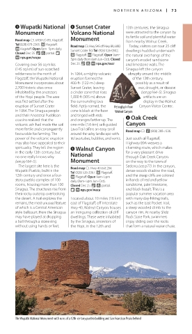
Covering over 56 sq miles Dec 25. & 7 ∑ nps.gov/sucr and limestone walls. The
(145 sq km) of sun-scorched Sinagua left the canyon
wilderness to the north of In 1064, a mighty vol canic abruptly around the middle
Flagstaff, the Wupatki National eruption formed the of the 13th century,
Monument incorpor ates about 400-ft- (122-m-) deep possibly as a result of
2,700 historic sites once Sunset Crater, leaving war, drought, or disease
inhabited by the ancestors a cinder cone that rises (see pp164–5). Sinagua
of the Hopi people. The area 1,000 ft (305 m) above artifacts are on
was first settled after the the surrounding lava display in the Walnut
eruption of Sunset Crater field. Aptly named, the Petroglyph from Canyon Visitor Center.
in 1064. The Sinagua people cone is black at the base Walnut Canyon
and their Ancestral Puebloan and tinged with reds 6 Oak Creek
cousins realized that the and oranges farther up. The
volcanic ash had made the soil one-mile (1.6-km) self-guided Canyon
more fertile and consequently Lava Trail offers an easy stroll Road map C3. n (800) 288-7336.
favourable for farming. The around the ashy landscape with
power of the volcanic eruption its lava tubes, bubbles, and vents. Just south of Flagstaff,
may also have appealed to their Highway 89A weaves a
spirituality. They left the region 5 Walnut Canyon char ming route, which makes
in the early 13th century, but National for a very pleasant drive
no one really knows why through Oak Creek Canyon
(see pp164–5). Monument on the way to the town of
The largest site here is the Road map C3. Hwy 40 exit 204. Sedona (see p77). In the canyon,
Wupatki Pueblo, built in the Tel (928) 526-3367. £ Flagstaff. dense woods shadow the road,
12th century and once a four- @ Flagstaff. Open 9am–5pm and the steep cliffs are colored
story pueblo complex of 100 daily (8am–5pm Jun–Oct). in bands of red and yellow
rooms, housing more than 100 Closed Dec 25. & 7 partial. sandstone, pale limestone,
Sinagua. The structures rise from 8 ∑ nps.gov/waca and black basalt. This is a
their rocky outcrop overlooking popular summer vacation area
the desert. A trail explores the Located about 10 miles (16 km) with many day-hiking trails,
remains, the most unusual feature east of Flagstaff, off Interstate such as the East Pocket Trail,
of which is a Central American- Hwy 40, Walnut Canyon houses a steep wooded climb to the
style ballcourt. Here the Sinagua an intriguing collection of cliff canyon rim. At nearby Slide
may have played at dropping dwellings. These were inhabited Rock State Park, swimmers
a ball through a stone ring by the Sinagua, ancestors of enjoy sliding over the rocks
without using hands or feet. the Hopi, in the 12th and that form a natural water chute.
The Wupatki National Monument with ruins of a 12th-century pueblo building and San Francisco Peaks behind
072-073_EW_SW_USA.indd 73 28/11/17 12:39 PM