
Page 174 - (DK Eyewitness) Travel Guide - Tokyo
P. 174
172 SUR VIV AL GUIDE
Using Trains in Tokyo
The fastest way of getting around Tokyo is by train. The
various systems that make up Tokyo’s train network – Toei
Subway and Tokyo Metro lines, overground Japan Railways
(JR) lines, and a number of private lines – are clean, efficient,
and punctual. Some of Tokyo’s huge stations can be daunting,
but the system is safe and fairly straightforward to negotiate,
with color-coded train lines and maps, directional arrows, and
bilingual signs. Trains run 5am–midnight daily; on some lines,
trains run approximately every 5 minutes at peak times. Avoid
rush hour (8–9am and 6–8pm) if possible, especially if you are
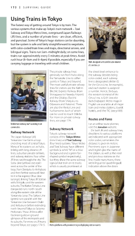
carrying luggage or traveling with small children. Well-designed and comfortable interior
of a metro car
The private railway lines the street-level entrance to
generally run from hubs along the subway. Besides being
the Yamanote Line to other color-coded, each subway
points in Tokyo and beyond. line is designated a letter (G
The most useful private railway for the Ginza Line, for example),
lines for visitors are the Keihin and each station is assigned
Electric Express Railway (from a number. Hence, Shibuya,
Shinagawa to Haneda Airport) the western terminal of the
and the Odakyu Electric Ginza Line, is G-01 (see also
Railway (from Shinjuku to Back Endpaper). Metro maps in
Odawara and Hakone). There English are available at all major
are also the Rinkai Line and train and metro stations, tourist
Yurikamome, both of which hotels, and the TIC (see p169).
can be used to reach Odaiba.
For more on private railway
lines, see page 174. Routes and Fares
Uniformed subway staff assisting train For an online route planner,
commuters visit the Jorudan website.
Subway Network On both JR and subway lines,
Railway Network
Tokyo’s subway network directions to various platforms
The Japan Railways’ (JR) consists of the Tokyo Metro are indicated with appropriate
Yamanote Line forms a loop (nine lines) and Toei Subway color codes; sometimes the
encircling most of central Tokyo. (four lines) systems. Tokyo Metro distance is given in meters.
Many of its stations act as hubs, and Toei Subway have different Prominent signs in Japanese
linking with long-distance JR symbols (a white “M” on a blue and English give the name of
lines, suburban private rail lines, background and a green fan- the station, as well as the next
and subway stations. Four other shaped symbol respectively), and previous stations on the
JR lines run through the city. The but they share the same subway line. Inside many trains, there
Sobu Line (yellow) cuts east– sign (a blue train on its track), are bilingual (or quadrilingual)
west across the center of the which is usually prominent at indicators above the doors
loop, from Shinjuku to Akihabara
and then farther eastward. Next
to it is the express Chuo Line
(orange), linking Tokyo JR Station
with Shinjuku and the western
suburbs. The Keihin Tohoku Line
(turquoise) runs north–south
along the eastern side of the
Yamanote Loop. The Saikyo Line
(green) runs parallel with the
Yamanote Line between Osaki
and Ikebukuro before extending
north beyond Tokyo to Saitama
Prefecture. These JR lines offer
fascinating above-ground
glimpses of the metropolis and
its suburbs. For more on JR trains
beyond Tokyo, see pages 174–5. Metro platform with prominent signs displaying station names
172-173_EW_Tokyo.indd 172 12/09/16 11:29 am