
Page 216 - (DK Eyewitness) Travel Guide - South Africa
P. 216
214 THE WESTERN AND SOUTHERN C APE
Lighthouse, the first to be seen
by ships coming from Europe.
Built in 1936, it is 80 m (263 ft) tall
and casts a beam visible for
about 50 km (31 miles). For a
small fee you can climb to the
top. Around a rocky headland
from Paternoster, the village of
St Helena perches at the edge of
a sheltered bay. Just before the
village a sign ed turnoff leads to
the monument commemorating
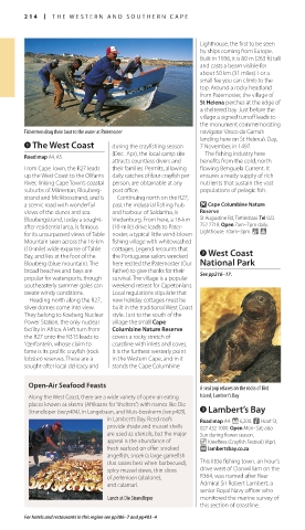
Fishermen drag their boat to the water at Paternoster navigator Vasco da Gama’s
landing here on St Helena’s Day,
1 The West Coast during the crayfishing season 7 November, in 1497.
(Dec–Apr), the local camp site The fishing industry here
Road map A4, A5.
attracts countless divers and benefits from the cold, north-
From Cape Town, the R27 leads their families. Per mits, allowing flowing Benguela Current. It
up the West Coast to the Olifants daily catches of four crayfish per ensures a ready supply of rich
River, linking Cape Town’s coastal person, are obtainable at any nutrients that sustain the vast
suburbs of Milnerton, Blouberg- post office. populations of pelagic fish.
strand and Melkbosstrand, and is Continuing north on the R27,
a scenic road with wonderful past the industrial fishing hub O Cape Columbine Nature
views of the dunes and sea. and harbour of Saldanha, is Reserve
Bloubergstrand, today a sought- Vredenburg. From here, a 16-km St Augustine Rd, Tietiesbaai. Tel 022
after residential area, is famous (10-mile) drive leads to Pater- 752 2718. Open 7am–7pm daily.
for its unsurpassed views of Table noster, a typical little wind-blown Lighthouse: 10am–3pm. &
Mountain seen across the 16-km fishing village with whitewashed
(10-mile) wide expanse of Table cottages. Legend recounts that 2 West Coast
Bay, and lies at the foot of the the Por tuguese sailors wrecked
Blou berg (blue mountain). The here recited the Paternoster (Our National Park
broad beaches and bays are Father) to give thanks for their See pp216–17.
popular for watersports, though survival. The village is a popular
south easterly summer gales can weekend retreat for Capetonians.
create windy conditions. Local regulations stipulate that
Heading north along the R27, new holiday cottages must be
silver domes come into view. built in the traditional West Coast
They belong to Koeberg Nuclear style. Just to the south of the
Power Station, the only nuclear village the small Cape
facility in Africa. A left turn from Columbine Nature Reserve
the R27 onto the R315 leads to covers a rocky stretch of
Yzer fontein, whose claim to coastline with inlets and coves.
fame is its prolific crayfish (rock It is the furthest westerly point
lobster) reserves. These are a in the Western Cape, and in it
sought-after local delicacy and stands the Cape Columbine
Open-Air Seafood Feasts A seal pup relaxes on the rocks of Bird
Along the West Coast, there are a wide variety of open-air eating Island, Lambert’s Bay
places known as skerms (Afrikaans for “shelters”) with names like Die 3 Lambert’s Bay
Strandloper (see p404), in Langebaan, and Muis-bosskerm (see p403),
in Lambert’s Bay. Reed roofs Road map A4. * 6,200. n Hoof St,
provide shade and mussel shells 027 432 1000. Open Mon–Sat; also
are used as utensils, but the major Sun during flower season.
appeal is the abundance of _ Kreeffees (Crayfish Festival) (Apr).
fresh seafood on offer: smoked ∑ lambertsbay.co.za
angelfish, snoek (a large gamefish
that tastes best when barbe cued), This little fishing town, an hour’s
spicy mussel stews, thin slices drive west of Clanwilliam on the
of perlemoen (abalone), R364, was named after Rear
and calamari. Admiral Sir Robert Lambert, a
senior Royal Navy officer who
Lunch at Die Strandloper moni tored the marine survey of
this section of coastline.
For hotels and restaurants in this region see pp386–7 and pp403–4
214-215_EW_South_Africa.indd 214 25/05/17 2:46 pm