
Page 286 - (DK Eyewitness) Travel Guide 2016 - Austria
P. 286
284 A USTRIA REGION B y REGION
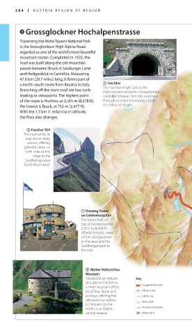
i Grossglockner Hochalpenstrasse
Traversing the Hohe Tauern National Park
is the Grossglockner High Alpine Road,
regarded as one of the world’s most beautiful
mountain routes. Completed in 1935, the
road was built along the old mountain
passes between Bruck in Salzburger Land
and Heiligenblut in Carinthia. Measuring
47.8 km (29.7 miles) long, it forms part of
a north–south route from Bavaria to Italy. 5 Hochtor
The Hochtor (High Gate) is the
Branching off the main road are two trails highest point along the Grossglockner
leading to viewpoints. The highest point Hochalpenstrasse. Here the road runs
of the route is Hochtor, at 2,505 m (8,218 ft), through a tunnel measuring 2.3 km
the lowest is Bruck, at 755 m (2,477 ft). (1.5 miles) in length.
With the 1.5 km (1 mile) rise in altitude,
the flora also changes.
6 Fuscher Törl
The road winds its
way above steep
ravines, offering
splendid views on
both sides of this
ridge to the
Goldberggruppe
(Gold Mountains).
J
7 Viewing Tower
on Edelweissspitze
The tower built on
top of Edelweissspitze
(2,572 m/8,438 ft)
affords fantastic views
of the Grossglockner
to the west and the
Goldberggruppe to
the east.
8 Alpine Naturschau
Museum
Situated at an altitude Key
of 2,260 m (7,415 ft) is Suggested route
a small museum of the
local flora, fauna and Other road
ecology, offering free Cable car
admission to visitors. River, lake
In Ferleiten, to the
north, is an Alpine Provincial border
animal reserve. Viewpoint
284-285_EW_Austria.indd 284 03/09/15 5:44 pm
Eyewitness Travel LAYERS PRINTED:
Catalogue template “UK” LAYER
(Source v2.1)
Date 5th December 2012
Size 125mm x 217mm