
Page 115 - (DK Eyewitness) Travel Guide - India
P. 115
DELHI & THE NOR TH 113
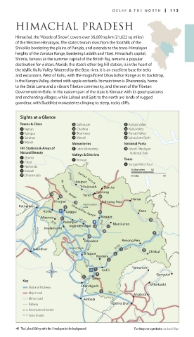
HIMACHAL PRADESH
Himachal, the “Abode of Snow”, covers over 56,000 sq km (21,622 sq miles)
of the Western Himalayas. The state’s terrain rises from the foothills of the
Shivaliks bordering the plains of Punjab, and extends to the trans-Himalayan
heights of the Zanskar Range, bordering Ladakh and Tibet. Himachal’s capital,
Shimla, famous as the summer capital of the British Raj, remains a popular
desti nation for visitors. Manali, the state’s other big hill station, is in the heart of
the idyllic Kullu Valley. Watered by the Beas river, it is an excellent base for treks
and excursions. West of Kullu, with the magnificent Dhauladhar Range as its backdrop,
is the Kangra Valley, dotted with apple orchards. Its main town is Dharamsala, home
to the Dalai Lama and a vibrant Tibetan community, and the seat of the Tibetan
Government-in-Exile. In the eastern part of the state is Kinnaur with its green pastures
and enchanting villages, while Lahaul and Spiti to the north are lands of rugged
grandeur, with Buddhist monasteries clinging to steep, rocky cliffs.
Sights at a Glance
Towns & Cities e Dalhousie q Kangra Valley
5 Nahan r Chamba y Kullu Valley
6 Rampur t Bharmour u Parvati Valley
7 Sarahan o Manali p Lahaul and Spiti
0 Mandi Monasteries National Parks
Hill Stations & Areas of a Tabo Monastery i Great Himalayan
Natural Beauty Valleys & Districts National Park
1 Shimla 9 Kinnaur Tours
2 Chail 8 Sangla Valley Tour
3 Narkanda
4 Kasauli 0 kilometres 50
w Dharamsala Chenab Pattan Valley 0 miles 50
Udaipur
Trilokinath Darcha
Keylong
Tandi
Pir Panjal Range
Hansa
Khajjiar Rohtang Pass
Pathankot Manimahesh
Lake
Kotla Gaggal Kaza
Dhauladhar Range
Masroor Naggar
Palampur NH 20
Beas Beas Manikaran
Jogindernagar
Jwalamukhi
NH1A
NH70 Rewalsar Rekong Peo
Jalandhar Govind Sagar NH 21 Sutlej NH 22 Chitkul
Bilaspur
NH 70
Naldera
Yamunotri
NH 88
Kufri
Gangotri
Solan
Key
Uttarkashi
National highway Chandigarh
Major road NH 72
Mussoorie
Minor road Ambala
Railway Dehra Dun
International border
State border
The Lahaul Valley with the Himalayas in the background For keys to symbols see back flap
112-113_EW_India.indd 113 26/04/17 11:43 am