
Page 120 - (DK Eyewitness) Travel Guide - India
P. 120
118 DELHI & THE NOR TH
Trekking in Himachal Pradesh
This mountainous state, with its vast variety of terrains,
offers a wide range of treks from easy one-day hikes to week-
long routes. At lower altitudes, trails wind through forests of HIMACHAL
oak, deodar (Cedrus deodara) and pine, while steeper climbs PRADESH
lead to flower-strewn alpine meadows above the tree line.
The towns of Manali and Dharamsala are starting points for
several popular treks. The best season for trekking is during
the month of June, and then later between mid-September Locator Map
and October, after the monsoon. During the rains (June– Area shown below
September), the trans-Himalayan cold deserts of Spiti (see
p134) and Upper Kinnaur are ideal destinations, completely
shielded from monsoon showers. 0 km 20
0 miles 20
Dharamsala to Macchetar
A challenging 75-km (47-mile) route crosses rocky
terrain to the meadows at Triund. A steep ascent leads
to the Indrahar Pass, with views of the Pir Panjal peaks,
and ends at the small town of Macchetar, connected
by road to Chamba.
Duration: 5 days
Altitude: 4,350 m (14,272 ft)
Level of difficulty: Moderate to tough
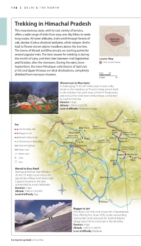
Gepang Goh
(6,050 m/19,849 ft)
Key Chamba
Bharmour Kailash
(5,656 m/18,556 ft)
The Pin Valley Trek Beas
Naggar to Jari Macchetar Kund Rohtang Pass
Indrahar Pass (3,985 m/13,074 ft) Kaza
Manali to Beas Kund (4,350 m/14,272 ft) Kuarsi Solang Palchan
Hanuman Tibba
Dharamsala to Macchetar Dharamkot Triund (5,930 m/19,455 ft) Manali
National highway Dharamsala Chanderkhani Pass Spiti Dankar
Major road Palampur Naggar • (3,500 m/11,483 ft)
Minor road Malana • Manikaran Mikkim
Peak Jari Khirganga Pin Pin Sangam
Kullu Pulga Valley
Pass Parvati Mud
Pandav Mantalai
Manali to Beas Kund Beas Beas Bridge
Starting at Palchan near Manali, a Pin Parvati Pass
30-km (19-mile) round trip to the (5,319 m/17,451 ft)
glacial lake of Beas Kund leads over Mandi
a glacial moraine to the lake,
surrounded by snow-clad peaks.
Duration: 3 days
Altitude: 3,980 m (13,058 ft)
Level of difficulty: Easy
Bilaspur Satluj
Naggar to Jari
This 40-km (25-mile) trek crosses the Chandrakhani
Pass, offering fine views of the peaks surrounding
Solang Nala, and leads past the isolated Malana
village (see p132) to end at Jari in Parvati Valley.
Duration: 4 days
Altitude: 3,500 m (11,483 ft)
Level of difficulty: Moderate
For keys to symbols see back flap
118-119_EW_India.indd 118 26/04/17 11:43 am
Eyewitness Travel LAYERS PRINTED:
Catalogue template “UK” LAYER
(Source v2.6)
Date 12th July 2013
Size 125mm x 217mm