
Page 85 - All About History - Issue 34-16
P. 85
Through History
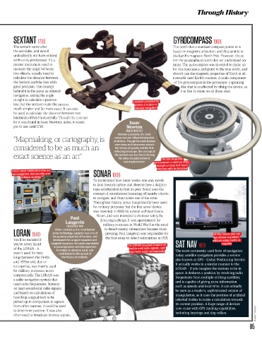
SEXTANT 1730 OCOMPASS 1906
The sextant came after orth that a standard compass points to is
the astrolabe, and would on magnetic attraction, and thus points to
undoubtedly not have existed rth’s magnetic North Pole. However, this is
without its predecessor. It’s a e geographical north that we understand on
precise instrument used to The gyrocompass was invented to make up
measure the angle between s inaccuracy and point to the true north, and
two objects, usually used to t use the magnetic properties of Earth at all;
calculate the distance betwee d it uses Earth’s rotation. A main component
the horizon and the Sun with gyrocompass is the gyroscope: a spinning
great precision. The concept isc that is unaffected by tilting the device, as
behind it is the same as celes is free to rotate on all three axes.
navigation, taking the angle
or sight to calculate a position A sextant provided far
line, but the sextant made the greater precision in
much simpler and far more e celestial navigation
be used to calculate the dista
landmarks if held horizontally
for it was found in Isaac Newtons notes, it wasn t Isaac
put to use until 1730. Newton
ENGLISH 1643-1727
Newton is possibly the most
“Mapmaking, or cartography, is of all time. Though his most famous
renowned and influential physicist
inventions and discoveries include
considered to be as much an the theory of gravity and the first
reflecting telescope, the concept of
exact science as an art” the sextant was also found among The non-magnetic
his notes decades before it
was implemented. gyrocompass is used on ships,
because a metal hull won’t
interfere with its function
Sonar’s most celebrated uses are
not navigation, but security and SONAR 1906
defence strategy
To understand how sonar works, one only n
to look towards nature and observe how a d
uses echolocation to find its prey. Sonar use
concept of soundwaves bouncing off nearby
to navigate, and thus makes use of the echo
Throughout history, sonar has primarily been used
for military purposes, but the first sonar device
was invented in 1906 by a naval architect Lewis
Nixon, and was intended to increase safety by
Paul
Langevin detecting icebergs. It was appropriated for
FRENCH 1872-1946 military purposes in World War I as the need
Often credited as the mind behind to detect enemy submarines became more
LORAN 1940 sonar technology, Langevin was one of pressing. Paul Langévin was responsible for Sat Nav means you can
the greatest physicists of his time, and
get almost anywhere
You’ll be excused if developed the Langevin equation and the first sonar to detect submarines in 1915. without using maths or
you’ve never heard Langevin dynamics. His work was related The LORAN required stations on SAT NAV 1973 magnets
to paramagnetism and diamagnetism
of the LORAN – it in relati t l t i d land to emit radio signals, and The most commonly used form of navigation
wasn’t used for very con was never used commercially today, satellite navigation provides a service
long (between the 1940s t also known as GPS – Global Positioning Service.
and 1970s) and, due to It actually works in a similar manner to the
its expense, was mainly used LORAN – if you imagine the stations to be in
for military purposes, never space. It deduces a position by receiving radio
commercially. The LORAN was frequencies from multiple orbiting satellites,
a radio navigation system that and is capable of giving extra information
used radio frequencies. Stations such as speeds and local time. It can actually
on land would emit radio signals, be seen as a modern, sophisticated version of
and based on calculations of triangulation, as it uses the position of artificial
how long a signal took to be celestial bodies to make a calculation towards
picked up in comparison to signal its current position. A huge range of devices
from other stations, it could be use now come with GPS tracking capabilities,
to determine position. It was also including keyrings and dog collars.
often used to broadcast distress si © Alamy, Thinkstock
85