
Page 459 - ANC-Presentations-Full-18-10_Neat
P. 459
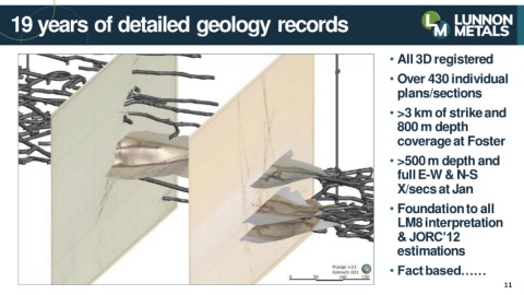
19 years of detailed geology records


                                                                                                                                                • All 3D registered


                                                                                                                                                • Over 430 individual


                                                                                                                                                   plans/sections


                                                                                                                                                • >3 km of strike and

                                                                                                                                                   800 m depth

                                                                                                                                                   coverage at Foster


                                                                                                                                                • >500 m depth and

                                                                                                                                                   full E-W & N-S


                                                                                                                                                   X/secs at Jan


                                                                                                                                                • Foundation to all

                                                                                                                                                   LM8 interpretation

                                                                                                                                                   & JORC’12


                                                                                                                                                   estimations


                                                                                                                                                • Fact based……


                                                                                                                                                                                          11