
Page 259 - NS-2 Textbook
P. 259
254 NAUTICAL SCIENCES
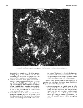
A composite satellite photograph showing typical cloud formations over the Northern Hemisphere.
large clouds are usually gray with darker spots or ing variety. The base of the cloud is the dark ninl-
shading. They do not produce rain, but they bus rain cloud. Severe thunderstorms and de-
sometimes fuse at the base and change into nim- structive tornadoes may come from these clouds,
bostratus. TIley usually precede bad weather. which normally are seen only in the Slffilffier.
4. Cumulus clouds are dense, puffy clouds with a
Middle Clouds. Middle clouds are basically strahlS or
beautiful, cauliflower-like appearance. On sum-
cumulus but with bases beginning about 10,000 feet.
mer days they look like giant cotton balls in the
They are denoted by the prefix 0110-:
sky. TIley rise by day in warm air and usually dis-
appear at night. Fleecy cumulus clouds usually 1. Altocumulus are gray or whitish layers of puffy,
mean fair weather ahead-unless the puffs begin fleecy clouds. These roll-like clouds are made of
to pile up and the dark edge of a nimbus rain water droplets, sometimes laid out in parallel
cloud starts to form at the base. bands. The Sun will sometimes produce a pale
5. Thlmderheads start at aimost any altitude and blue or yellow corona through altocumulus
sometimes extend to heights of as much as 75,000 clouds. TI,e presence of these clouds means that
feet. Cumulonimbus is the name given to these rain will probably occur within twenty-four
clouds. They are very dense clouds of the tower- hotu's.