
Page 282 - NS-2 Textbook
P. 282
METEOROLOGY 277
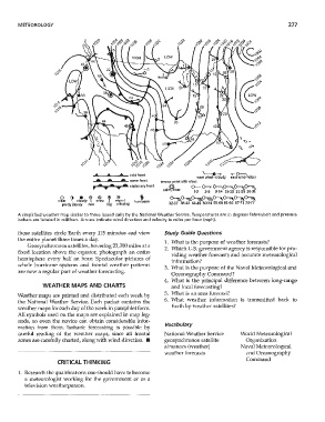
C)rV' n-'O ~I(.. ~IO r?CO r?'(...
'" ,() ,C) ,0 ,C) ,tJ
5
............ _ ....... _ ..... "- cold front '----e- -~
west wind-cloudy east wind---'{;lear
...... ·"-......... "-...... ·IIL warm front arrows point with wind:
, ." • ... • stationary front @ 0-- 0--,. O-,p-~o-----..~
calm, clear 1.2 3-8 9·14 15.20' 21-25 26-31
o G • ® ® ® ® § ~~~~~~~~
clear \ cloudy I sncm.1 rep'o~ hurricane
partly ctoudy rain fog missing 32-37 38-43 44·49 50·54 55·60 61·66 67·71 72-77
A simplified weather map similar to those issued daily by the National Weather Service. Temperatures are in degrees Fahrenheit and pressure
isobars are labeled in millibars. Arrows indicate wind direction and velocity in miles per hour (mph).
these satellites circle Earth every 115 minutes and view Study Guide Questions
the entire planet three times a day.
1. What is the purpose of weather forecasts?
Geosynchronous satellites, hovering 22,300 miles at a
2. Which U.S. government agency is responsible for pro-
fixed location above the equator, photograph an entire
viding weather forecasts and accurate meteorological
hemisphere every half an hour. Spectacular pictures of
information?
whole hurricane systems and frontal weather patterns
3. What is the purpose of the Naval Meteorological and
are now a regular part of weather forecasting.
Oceanography Command?
4. What is the principal difference between long-range
WEATHER MAPS AND CHARTS and local forecasting?
5. What is an area forecast?
Weather maps are printed and distributed each week by
6. What weather information is transmitted back to
the National Weather Service. Each packet contains the
Earth by weather satellites?
weather maps for each day of the week in pamphlet form.
All symbols used on the maps are explained in map leg-
ends, so even the novice can obtain considerable infor-
Vocabulary
mation from them. Isobaric forecasting is possible by
careful reading of the weather maps, since all frontal National Weather Service World Meteorological
zones are carefully charted, along with wind direction. III geosynchronos satellite Organization
almanacs (weather) Naval Meteorological
weather forecasts and Oceanography
Command
CRITICAL THINKING
1. Research the qualifications one should have to become
a meteorologist working for the govenunent or as a
television weatherperson.