
Page 26 - Social Studies 7
P. 26
total population is 45,34,943 as per the census,
2011 AD. The highest peak of the world, Mt.
Everest (8,848 m), Mt. Kanchanjunga (8,586
m), Lhotse (8,516 m), Makalu (8,485 m),
Choyu (8,586 m), Nuptse (7,555 m) and
Pumori (7,161 m) are the major peaks
which lie in this region. National Parks
and Conservation Areas like Kanchanjunga
Conservation Area, Koshi Tappu Wildlife
Reserve, Makalu Barun National Park
and Sagarmatha National Park also lie in this
region.
Religious Sites like Pathivara and Haleshi Mahadev
are major pilgrimage sites of this region. Various caste and
ethnic groups like Brahmins, Chhetris, Limbu, Sherpa, Rai, Tharu, Rajbhanshi,
Dhimal, Magar etc. live in this region. The literary rate of this region is 78.3
percent. People in the Terai depend upon agriculture and industries while the
major occupation of the mountainous region is tourism. All the 14 districts of
Eastern Development Region except Saptari and Siraha lie in this province. The
province consists of 1 metropolitan city, 2 sub-metropolitan cities, 46 municipalities
and 88 Gaunpalikas.
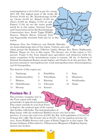
The districts of this region are:
1. Taplejung, 2. Panchthar, 3. Ilam,
4. Sankhuwasabha, 5. Tehrathum, 6. Dhankuta,
7. Bhojpur, 8. Khotang 9. Solukhumbu,
10. Okhaldhunga, 11. Udayapur 12. Jhapa
13. Morang 14. Sunsari
Province No. 2
This province elongates only in
the Terai region with high
potentiality of agricultural production.
This region extends its area from Parsa
to Saptari, the southern part of the country
that borders with India. The historical palace of
King Janak, with the traditional Maithili society also lies in this
province. It covers the total area of 9,661 Sq. Km. with population of 54,04,145
(Census 2011 AD). The literary rate is 49.54%. It is the smallest province by
area. Parsa Wildlife Reserve and a part of Koshi Tappu lie in this region. The
famous Gadimai of Bara district, Chhinamasta Bhagwati of Rajbiraj,Saptari
district also lie here.
Dynamic Social Studies and Population Education - Book VII 26