
Page 29 - GeoPRISMS_Newsletter_Spring2019_42_Neat
P. 29
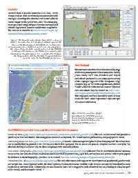
Cascadia
        Derived from Cascadia Initiative OBS data, Emily
        Morton and Sue Bilek contributed a new microseismicity
        catalogue of earthquakes detected and located offshore
        central Oregon for the period 2011-2015. The catalog (Fig.
        3) was generated using a subspace detection technique and
        includes hypocentral locations and duration magnitudes.
        The data set is available at http://www.marine-geo.org/
        tools/search/entry.php?id=Cascadia_Morton

          Figure 3. This Cascadia region image shows 10 km contours of
          depth to the subduction slab interface from McCrory et al. The
           microseismicity catalogue from Emily Morton is displayed as
        dots coloured on focus depth and scaled on duration magnitude.
          The red arrows are geodetic velocity vectors from the UNAVCO
           EarthScope PBO solutions in the IGS08 reference frame, with
          10mm of arrow length equivalent to a velocity of 10 mm/year.
             The image is made with GeoMapApp. The geodetic data is
                     available under the GeoMapApp Portals menu.


                                                                   New Zealand

                                                                   To better understand the forces that drive early-stage
                                                                   subduction, investigators Mike Gurnis, Sean Gulick,
                                                                   Joann Stock, Harm Van Avendonk and Rupert
                                                                   Sutherland conducted a 2-D active-source survey
                                                                   of the Puysegur segment of the Macquarie Ridge
                                                                   Complex (Fig. 4). The 2018 Langseth cruise, dubbed
                                                                   “SISIE”, collected multi-channel seismic reflection
                                                                   data sets which may be viewed at: http://www.
                                                                   marine-geo.org/tools/search/entry.php?id=MGL1803
                                                                   This Puysegur-Fiordland boundary south of New
                                                                   Zealand’s South Island represents a type-example
                                                                   of incipient subduction.


                                                                Figure 4. Seismic survey lines (bright
                                                                yellow) from the 2018 SISIE survey of
                                                                Gurnis et al. The background elevation
                                                                map is the Global Multi-Resolution
                                                                Topography (GMRT) synthesis.


        GeoPRISMS Data Portal Tools and Other Relevant IEDA Resources

        Search For Data - (http://www.marine-geo.org/tools/new_search/index.php?funding=GeoPRISMS) The GeoPRISMS search tool provides a
        quick way to find GeoPRISMS data using parameters such as keyword, NSF award number, publications, and geographical extent.

        Data Management Plan tool - (www.iedadata.org/compliance) Generate a data management plan for your NSF proposal. The online form
        can be quickly filled in, printed in PDF format, and attached to a proposal. PIs can use an old plan as a template to create a new plan. We
        also have developed a tool to help PIs show compliance with NSF data policies.
        GeoPRISMS Bibliography – (http://www.marine-geo.org/portals/geoprisms/references.php) With more than 90 GeoPRISMS-funded citations,
        many tied to data sets, the references database can be searched by primary site, paper title, author, year, and journal. Submit your papers
        for inclusion in the bibliography – just the DOI is needed! http://www.marine-geo.org/portals/geoprisms/ref_submit.php
        Contribute Data - (http://www.iedadata.org/contribute) The web submission tools support PI contributions of geophysical, geochemical,
        and sample data. Once registered within the IEDA systems, the data sets become available to the broader community immediately or may
        be placed on restricted hold. Additionally, PIs can choose to have a DOI assigned to each submitted data set, allowing it to become part
        of the formal, citable scientific record. ■
                                                                          Spring 2019  Issue No. 42  GeoPRISMS Newsletter  •  29