
Page 39 - SOA 109
P. 39
HighunDry for Options
returning. We were once again surrounded by water, it appeared we could
just float away.
Day #10 A beautiful day. Using our “Long Pole” we measured the depth of
water to be 60cm at HW 0650hrs. In the evening at HW 1905hrs the depth
was 76cm and the stern of the boat moved a little. We were tantalisingly
close to lift off! We needed at least 80cm and ideally
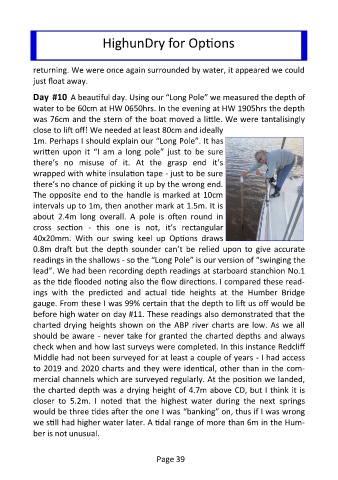
1m. Perhaps I should explain our “Long Pole”. It has
written upon it “I am a long pole” just to be sure
there’s no misuse of it. At the grasp end it’s
wrapped with white insulation tape - just to be sure
there’s no chance of picking it up by the wrong end.
The opposite end to the handle is marked at 10cm
intervals up to 1m, then another mark at 1.5m. It is
about 2.4m long overall. A pole is often round in
cross section - this one is not, it’s rectangular
40x20mm. With our swing keel up Options draws
0.8m draft but the depth sounder can’t be relied upon to give accurate
readings in the shallows - so the “Long Pole” is our version of “swinging the
lead”. We had been recording depth readings at starboard stanchion No.1
as the tide flooded noting also the flow directions. I compared these read-
ings with the predicted and actual tide heights at the Humber Bridge
gauge. From these I was 99% certain that the depth to lift us off would be
before high water on day #11. These readings also demonstrated that the
charted drying heights shown on the ABP river charts are low. As we all
should be aware - never take for granted the charted depths and always
check when and how last surveys were completed. In this instance Redcliff
Middle had not been surveyed for at least a couple of years - I had access
to 2019 and 2020 charts and they were identical, other than in the com-
mercial channels which are surveyed regularly. At the position we landed,
the charted depth was a drying height of 4.7m above CD, but I think it is
closer to 5.2m. I noted that the highest water during the next springs
would be three tides after the one I was “banking” on, thus if I was wrong
we still had higher water later. A tidal range of more than 6m in the Hum-
ber is not unusual.
Page 39