
Page 261 - (DK Eyewitness) Travel Guide - Morocco
P. 261
HIGH A TLAS 259
VISITORS’ CHECKLIST
Practical Information
Agouti. Road Map C3. Accessible
on road N8 from Marrakech, then
road R208 to Azilal, continuing
south and, before Aït Mhamed,
turning right then left to Agouti.
The road is metalled as far as
Tabant, but with a four-wheel-
drive vehicle it is possible to
reach Zaouïa Ahansal then Bin
el-Ouidane. 8 Guides and
mules can be hired in Tabant
and other villages. Guesthouse
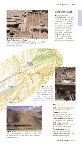
Maize Drying on the Rooftops accommodation is also available.
In the autumn, maize is laid out carefully on the tiered rooftops.
When it has dried, the grain is separated from the cob on a
concrete floor by hand.
Bin El-Ouidane
Tizi-n-Ilissi
2,603 m
(8,540 ft)
Jbel Aroudane
3,359 m
(11,020 ft)
Jbel Azourki . Souk in El-Had
3677 m
(12,064 ft) The Sunday souk,
with weekly deliveries
arriving by truck, provides
the local inhabitants with
necessities, such as tea, coffee,
sugar, matches, oil and utensils,
that they cannot otherwise obtain.
Izourar Lake
KEY
1 Zaouïa Oulemsi is the departure
point for hikes to Lake Izourar.
2 Tabant is the valley’s
administrative centre. The souk at
El-Had takes place on Sundays.
3 The restored circular granary in
Sidi Moussa is famous in the region.
4 The direct route to Aït
Mohammed is best avoided. Instead
take the easier road from Agouti.
5 Zaouïa Ahansal contains
Valley Landscape Drawn to the pastures in the region, tighremts, old fortified houses.
the industrious Berbers have irrigated the land so as to 6 Many nomadic herdsmen camp
extract the most from it, and built fortified villages to on the shores of Lake Izourar.
ensure their safety.
For keys to symbols see back flap
258-259_EW_Morocco.indd 259 09/08/16 11:19 am