
Page 263 - (DK Eyewitness) Travel Guide - Morocco
P. 263
HIGH A TLAS 261
Aït Ziri, Timit, Imelghas
and Iskattafène
East of Agouti. ( at El-Had on Sun.
Walking around these villages,
visitors will observe such details
as decorated doors (either carved
or painted in bright colours)
and windows with interlacing
wrought iron or mashrabiyya
screens. Some very fine tighremts
(fortified houses) dating from
the early 20th century are still
inhabited by village chiefs
and their large families.
Close to Tabant, the Cultivated fields in the Aït Bouguemez valley
administrative centre of the
valley, El-Had is well known carefully controlled to prevent 2,629 m (8,628 ft). The
for its Sunday souk. This is the over-grazing. mountains are very bare here.
only place in the valley where The shepherds include the Aït The track passes a “fossilized
supplies can be purchased. Bouguemez, who forest” of juniper,
The village is also the starting come for the summer, with gnarled, dying
point for mountain hikes to living in the stone- trunks; the species
the M’Goun. built sheepfolds, and faces extinction.
the Aït Atta, with Zaouïa Ahansal,
Zaouïa Oulemsi their sheep, goats consisting of some
On the way from Agouti, on a and camels, who in old tighremts and
narrow track. summer come up to the tomb of its
Zaouïa Oulemsi is the last the High Atlas from founder, Saïd Ahansal,
village in the Aït Bouguemez Jbel Sarhro. Seeking dates from the 14th
valley, which it overlooks from good pasture, they Fortified granary, Aït century, when the
an altitude of 2,150 m (7,056 ft). settle on the slopes Bouguemez valley marabout movement
It consists of low, red-hued dry- of M’Goun, around loomed large in the
stone houses. Here, the snowfall Lake Izourar or on history of this mountain region.
comes early and tends to the Imilchil plateau, moving Zaouias (sanctuaries set up
be heavy. south again at the first frosts. around the tombs of marabouts,
The village is the starting point holy figures and the leaders
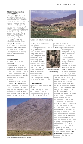
for hikes to Lake Izourar, which Zaouïa Ahansal of brother hoods) were then
lies in the heart of the mountains On the track towards Bin el-Ouidane. protected holy places, where
at an altitude of 2,500 m (8,205 ft). ( Mon. pilgrims and the needy found
Many nomadic shepherds camp A track running along the refuge. In exchange for the
beside the lake, which is often continuation of the Aït protection given by the
dry in summer, when it turns into Bouguemez valley goes up marabout, the Berbers maintained
pasture, the use of which is to the Tizi-n-Tirrhist Pass, at the land around the zaouia,
were taught Arabic and
received Koranic instruction.
Heedless of the power of
the sultans, the leaders of some
zaouias controlled the lives of
the mountain people, settling
disputes over land ownership
and imposing their will. Zaouïa
Ahansal was a major influence
on the local Berber populations,
but the descendants of Saïd
Ahansal came into conflict with
the fiefs of the caids (chief of a
defined territory) of the High
Atlas. They held out against
the French until 1934.
The track continues for 40 km
(25 miles) before reaching La
Cathédrale, an impressive rock
formation, then Lake Bin
Animals grazing around Lake Izourar, in summer el-Ouidane.
260-261_EW_Morocco.indd 261 09/08/16 11:19 am