
Page 280 - (DK Eyewitness) Travel Guide - Morocco
P. 280
278 MOROC C O REGION B Y REGION
Wadi Todra flows through this
great geological fault and on
into the Tinerhir palm grove
(see above).
Two hotels make possible
an overnight stop in the Todra
gorge. The best time of day
to view the gorge is in the
morning, when the rays of the
sun break through between
the high cliffs on either side.
The cliffs soon widen and a
stony track leads to the village
of Tamtattouchte, 22 km
(14 miles) further on.
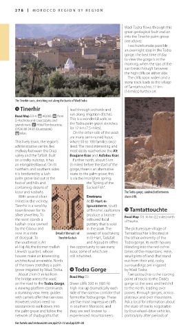
The Tinerhir oasis, stretching out along the banks of Wadi Todra
e Tinerhir lead through orchards and
run along irrigation ditches.
Road Map D3-4. * 40,000. @ from
Er-Rachidia and Ouarzazate, and This is a wonderful walk, as
grands taxis. n Hôtel Tombouctou; the Todra palm grove stretches
(0524) 88 24 85 (Ouarzazate). for 12 km (7.5 miles).
( Mon. On the other side of the wadi
are many semi-ruined ksour,
This lively town, the region’s where 50 to 100 families once
administrative centre, lies lived. The most interesting and
midway between the Draa most easily reached are the Aït
valley and the Tafilalt. Built Boujane Ksar and Asfalou Ksar.
on a rocky outcrop, it has Further north, about 5 km
an elongated layout. On its (3 miles) before the start of the
northern and southern sides gorge, there is an alternative
it is bordered by a lush route to the palm grove; this
palm grove laid out at the is via the Imarighen spring,
foot of arid hills and the “Spring of the
containing dozens of Sacred Fish”.
ksour and kasbahs. The Todra gorge, sandwiched between
With several silver Environs sheer cliffs
mines in the vicinity, At El-Hart-n-
Tinerhir is a wealthy Igouramene, south
town known for its of Tinerhir, craftsmen t Tamtattouchte
silver jewellery. To produce a bronze- Road Map D3. 36 km (22 miles) north
the west stands a coloured local of Tinerhir.
kasbah once owned pottery that is sold
by the Glaoui and in the souk. The The picturesque village of
now in a state Detail of the walls of sweep of road taking Tamtattouchte is located at
of disrepair. To Tinerhir Kasbah in El-Hart, Tadafalt the other extremity of the
the southeast is Aït and Agoudim offers Todra gorge, its earth houses
el-Haj Ali, the former mellah the opportunity to see many blending into the red-ochre
(Jewish quarter), whose ksour, some of which are tones of the mountains. Here,
houses make an interesting still inhabited. small plots of land that stand
architect ural ensemble. North out from their arid, rocky
of the town stretches a palm surroundings are irrigated
grove irrigated by Wadi Todra. r Todra Gorge by Wadi Todra.
About 2 km (1 mile) from Road Map D3. Tamtattouchte is the starting
the bridge across the wadi, point of tracks to the Dadès
on the road to the Todra Gorge, Sheer cliffs 300 m (985 ft) gorge to the west and Imilchil
a viewing platform commands high rise up dramatically each to the north, leading over
a stunning view. Here, guides side of the narrow corridor that passes, through gorges, across
with camels offer their services. forms the Todra gorge. These plateaux and over mountains.
However, visitors need no are the most impressive cliffs Ask a local for information about
assistance to walk down into in southern Morocco, and the state of tracks negotiable
the palm grove and follow the they are well known to by four-wheel-drive vehicles,
network of shady paths that experien ced mountaineers. particularly after periods of
For hotels and restaurants see pp312–13 and pp329–30
278-279_EW_Morocco.indd 278 09/08/16 11:20 am
Eyewitness Travel LAYERS PRINTED:
Catalogue template “UK” LAYER
(Source v2.7)
Date 1st October 2013
Size 125mm x 217mm