
Page 285 - (DK Eyewitness) Travel Guide - Morocco
P. 285
OU ARZAZA TE & THE SOUTHERN O ASES 283
Ksour in the Oases
The Ziz valley is ksar country. The ksar (plural ksour) was
developed originally as a communal stronghold for sedentary
populations, to protect them against the incursions of bandits
and nomadic tribes that raided
the oases when the harvests had
been brought in. The defensive
design of these fortified villages
is connected to this warlike past.
The ksar usually overlooks the
oasis. Originally, the ksar consisted
of no more than a central alley
with family houses on each side.
Over time, it expanded to become
a village, with a mosque, a medersa
and granaries. Built of pisé and
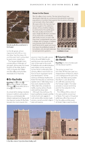
Dates drying after the autumn harvest in earth bricks in its upper part, every
the Ziz gorge ksar bears the individual stamp of
its builders, who devised elaborate Detail of the ksar of Oulad
to the Ziz gorge, whose incised geometric patterns. Abdelhalim in Rissani
impressive red cliffs jut into
the Atlas. Two fine ksour, Ifri
and Amzrouf, both surrounded province. Here the palm groves p Source Bleue
by palm trees, stand here. of the Ziz and Tafilalt begin, de Meski
The Hassan-Addakhil dam, and the town also stands at the
contained by a thick dyke of start of the road to the south. Road Map E3. 23 km (14 miles) south
red earth, demarcates the lower Er-Rachidia, also an administrative of Er-Rachidia on road N13.
foothills of the Atlas. Built in and military centre, was built
1970, it irrigates the Tafilalt by the French in the early 20th The spring, located 1 km
and Ziz valleys and provides century, when it was known as (0.6 mile) off the main road, is a
electricity for Er-Rachidia. Ksar es-Souk. Its present name reappearance of Wadi Ziz, which
was bestowed in 1979 in runs underground for part of its
memory of Moulay Rachid, the course. The blue spring waters
o Er-Rachidia first of the Alaouites to overthrow flow from a cave at the foot
Saadian rule in 1666. Many ksour of a cliff into a pool built by
Road Map D3. * 62,000. k
@ from Erfoud, Midelt, Ouarzazate here were abandoned after the Foreign Legion. The water
and Figuig. n Tourist office; (0535) 57 1960, when the Ziz broke its provides a natural swimming
09 44. ( Tue, Thu & Sun. banks, causing serious floods pool for the campsite in the
and washing away land. palm grove.
As a result of its strategic location Although they are busy, the The clifftop offers a view of
between northern and southern town’s perfectly straight, gridlike the oasis and the ruined ksar
Morocco, and between the streets hold scant appeal. A of Meski. The road to Erfoud (see
Atlantic seaboard and Figuig and craft centre offers locally made p284) also offers fine views of
the Algerian border, Er-Rachidia pottery, carved wooden objects the Ziz valley and the oases
became the main town in the and rush baskets. of Oulad Chaker and Aourfous.
Er-Rachidia, a town at the junction of roads leading south
282-283_EW_Morocco.indd 283 09/08/16 11:20 am