
Page 140 - (DK Eyewitness) Travel Guide - Greek Islands
P. 140
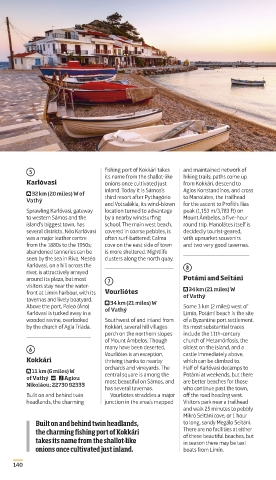
5 fishing port of Kokkári takes and maintained network of
its name from the shallotlike
hiking trails; paths come up
Karlóvasi onions once cultivated just from Kokkári, descend to
inland. Today it is Sámos’s Agios Konstandínos, and cross
⌂ 32 km (20 miles) W of
Vathý third resort after Pythagório to Manolátes, the trailhead
and Votsalákia, its windblown for the ascent to Profítis Ilías
Sprawling Karlóvasi, gateway location turned to advantage peak (1,153 m/3,783 ft) on
to western Sámos and the by a nearby windsurfing Mount Ámbelos, a fivehour
island’s biggest town, has school. The main west beach, round trip. Manolátes itself is
several districts. Néo Karlóvasi covered in coarse pebbles, is decidedly touristgeared,
was a major leather centre often surfbattered; Calma with upmarket souvenirs
from the 1880s to the 1950s; cove on the east side of town and two very good tavernas.
aban doned tanneries can be is more sheltered. Nightlife
seen by the sea in Ríva. Meséo clusters along the north quay.
Karlóvasi, on a hill across the 8
river, is attractively arrayed
around its plaza, but most 7 Potámi and Seïtáni
visitors stay near the water ⌂ 34 km (21 miles) W
front at Limín harbour, with its Vourliótes of Vathý
tavernas and lively boatyard. ⌂ 34 km (21 miles) W
Above the port, Paleó (Áno) of Vathý Some 3 km (2 miles) west of
Karlóvasi is tucked away in a Limín, Potámi beach is the site
wooded ravine, overlooked Southwest of and inland from of a Byzantine port settlement.
by the church of Agía Triáda. Kokkári, several hill villages Its most substantial traces
perch on the northern slopes include the 11thcentury
of Mount Ámbelos. Though church of Metamórfosis, the
6 many have been deserted, oldest on the island, and a
Vourliótes is an exception,
castle immediately above,
Kokkári thriving thanks to nearby which can be climbed to.
orchards and vine yards. The Half of Karlóvasi decamps to
⌂ 11 km (6 miles) W
of Vathý @ n Agíou central square is among the Potámi at weekends, but there
most beautiful on Sámos, and
are better beaches for those
Nikoláou; 22730 92333
has several tavernas. who continue past the town,
Built on and behind twin Vourliótes straddles a major off the road heading west.
headlands, the charming junction in the area’s mapped Visitors park near a trailhead
and walk 25 minutes to pebbly
Mikró Seïtáni cove, or 1 hour
Built on and behind twin headlands, to long, sandy Megálo Seïtáni.
the charming fishing port of Kokkári There are no facilities at either
takes its name from the shallot-like of these beautiful beaches, but
in season there may be taxi
onions once cultivated just inland. boats from Limín.
140
140-141_EW_Greek_Islands.indd 140 28/11/2018 09:52
EW Must-see / Catalogue template v1.1 – 18th May 2018
Fonts: Aptifer Sans LT Pro, Posterama Text, Soho Gothic
Pro, Soho Pro, ITC Caslon 224