
Page 125 - How It Works - Book of Amazing Answers To Curious Questions, 12
P. 125
It's all made
How do satnavs possible by satellites
orbiting the Earth at
lmowwhere you are? over 8,ooomph ...
0 rbiting the planet n,ooo miles above us, far away the satellite is and its direction. Once position. The more signa Is you receive, the more
satellites are constantly sending signals the receiver has this information from three accurate the results will be during the journey.
down to Earth. These satellites and GPS different satellites it can start calculating your New systems will become available over the
technology started out as part of the USA's position, using triangulation. There are 12 next few years that improve on the average 15m
military attempt to improve missile accuracy. satellites on each side ofthe Earth at any one accuracy. These systems rely on new satellites
The satellites send a constant stream of time, as they have to cover the whole planet. that orbit to stay in exactly the same position,
signals broadcasting their exact position to These will be at different positions in the sky. and ground stations to relay the signals. In
Earth, where a GPS or satnav system can receive Once you have four satellite signals, your Europe the system in development is called
it. The signal sent to your receiver will tell it how receiver can start to calculate altitude as well as EGNOS and promises accuracy to 2m.
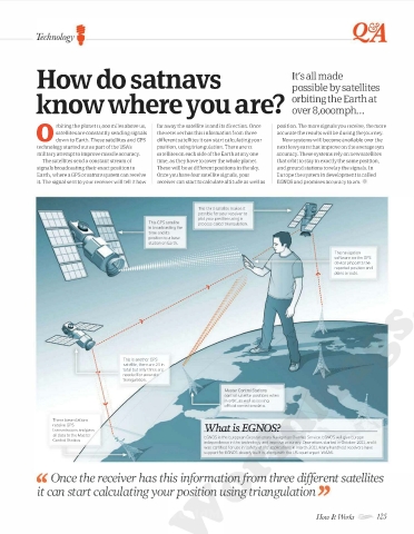
This third satellite makes it
possible for your receiver to
plot your position using a
process called triangulation.
The navigation
software on the GPS
. device pinpoints the
. reported position and
.
"\' plans a route.
'
'
'
.
This is another GPS
'
satellite, there are 24 in
total but only three are
.y
needed for accurate
' triangulation .
.
'
'
. control satellite positions when
'
in orbit, as well as issuing
official correction data.
These base stations
receive GPS
transmissions and pass
all data to the Master EGNOS is the European Geostationary Navigation Overlay Service. EGNOS will give Europe
Control Station. independence in the technology and improve accuracy. Operations started in October 2011, and it
/ was certified for use in 'safety of life' applications in March 2011. Many handheld receivers have
support for EGNOS already built in, along with the US counterpart WAAS.
/
'' Once the receiver has this information from three different satellites
it can start calculating your position using triangulation ''
WorldMags.net
WorldMags.net How It Works 125