
Page 213 - (DK Eyewitness) Travel Guide - The Netherlands
P. 213
UTRECHT 211
One of the country’s largest u Rhenen
gardens, it is home to ten huge Road Map C4. * 19,000. £ @
sequoia trees and a collection of n Markt 20 (0317-612333). ( Thu.
rhodo-dendrons. Although best
visited in spring and summer to Rhenen lies on the north bank
see (and smell) the flowers in of the Rhine, at the border
bloom, the gardens contain plants between the flat Betuwe and
for all seasons. the Utrecht Heuvelrug. This area
was inhabited as far back as the
+ Huis Doorn Iron Age. Many of the town’s
Langbroekerweg 10. Tel 0343-421020. historic buildings were destroyed
Open 1–5pm Wed–Fri, noon–5pm Sat during World War II, but the Late
& Sun. 8 mandatory. & 7 = Gothic Cuneratoren (Cunera
∑ huisdoorn.nl tower), built between 1492 and
Y Von Gimborn Arboretum 1531, escaped the bombs. The
Velperengh 13. Tel 0343-412144 Raadhuis (town hall) dates from
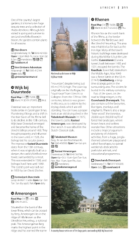
Open daily. & Medieval castle tower in Wijk the Middle Ages. May 1940
∑ gimbornarboretum.nl bij Duurstede saw a fierce battle on the 53-m
(174-ft) Grebbeberg, a long-
“mountain”, despite being just time strategic point in the
t Wijk bij 69 m (225 ft) high. The town lay surrounding area. The victims lie
Duurstede originally on the Via Regia, the buried in the military cemetery.
East of the town, on the
“royal route” from Utrecht to
Road Map C4. * 23,000. @ Cologne. From the 17th to 19th road to Wageningen, is the
n Markt 24 (0343-575995). ( Wed. centuries, tobacco was grown Ouwehands Dierenpark. This
in this area, as is evident by the zoo contains all the favourites,
Dorestad was an important drying sheds which are still like tigers, monkeys and
trade centre in Carolingian times. standing. You can have a proper elephants. There is also a large
Plundering Vikings and a shift in look at an old drying shed in the “bear wood”, the berenbos,
the river basin of the Rhine led Tabaksteelt Museum. In 1672, 20,000 sq m (66,000 sq ft) of
to its decline. In the 13th century, the town’s castle, Kasteel forest-like landscape, where
Wijk (near Dorestad) emerged Amerongen, was destroyed by brown bears and wolves
and became the home of the the French. It was rebuilt in the wander free. Other attractions
Utrecht bishops around 1450. They Dutch Classical style. include a tropical aquarium
brought prosperity and influence and plenty of children’s
to the town until, in 1528, the E Tabaksteelt Museum activities, from a huge, jungle-
bishop lost his secular power. Burg. Jhr van den Boschstraat 46. themed adventure playground
The impressive Kasteel Duurstede Tel 0343-456500. Open Tue–Sun pm. called RavotAapia, to special
dates from the 13th century, 7 & weekends dedicated to
when it was originally built as a + Kasteel Amerongen particular animals, and
donjon, the castle’s fortified inner Drostestraat 20. Tel 0343-563766. educational programmes.
tower, surrounded by a moat. Open Apr–Oct: 11am–5pm Tue–Sun;
This was extended in 1500, and Nov–Mar: 11am–5pm Thu–Sun. Y Ouwehands Dierenpark
bishops lived here until 1580. & 8 mandatory. Grebbeweg 111. Tel 0317-650200.
The castle’s park was laid out ∑ kasteelamerongen.nl Open daily. ∑ ouwehand.nl
in 1850 by Jan David Zocher.
Y Kasteelpark Duurstede
Langs de Wal 7. Castle: Open Apr–Oct:
Tue–Sun (by appt). Park: Open daily.
y Amerongen
Road Map C4. * 7,000. @
n 0343-412015.
Situated on the bank of the
lower Rhine, which can be crossed
by ferry, Amerongen lies in the
ridge of hills known as the
Utrechtse Heuvelrug, a national
park. The Ameron gense Berg
marks the highest point in the
ridge and has earned the name A country house set in one of the large parks surrounding Wijk bij Duurstede
210-211_EW_Netherlands.indd 211 16/01/17 12:05 pm