
Page 85 - (DK Eyewitness) Travel Guide - The Netherlands
P. 85
OUDE ZIJDE 83
the four points of the compass.
No expense was spared on
the construction and internal
decoration of the building, and
local dock workers came to
regard the building as a symbol
of capitalism. The doors, stairs,
window frames and interior
walls are festooned with nautical
images, such as sea horses,
dolphins and anchors. Beautiful
stained-glass skylights are also
decorated with images of sailing
ships, maps and compasses.
The Scheepvaarthuis is now
a luxury hotel, the Grand Hôtel
Amrâth, which offers guided
tours for groups.
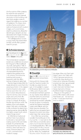
o Schreierstoren
Prins Hendrikkade 94–95. Map 2 E4.
v 1, 2, 4, 5, 9, 11, 13, 16, 17. q Centraal
Station. Closed to the public.
The Schreierstoren (weepers’
tower) was a defensive structure
forming part of the medieval
city walls, dating from 1480. It
was one of the few fortifications
not to be demolished as the The Schreierstoren, part of the original city fortifications
city expanded beyond its
me dieval boundaries in the p Zeedijk the edge of the city’s Red Light
17th century. The distinctive Map 2 E4. v 1, 2, 4, 5, 9, 13, 16, 17. District, and in the 1960s and
building now houses a q Nieuwmarkt, Centraal Station. 1970s it became notorious as
basement café that offers a centre for drug-dealing and
tastings of genuine sailors’ gin. Along with the Nieuwendijk street crime. However, following
Popular legend states that the and the Haarlemmerdijk, the an extensive clean-up campaign
tower derived its name from the Zeedijk (sea dyke) formed in the 1980s, the Zeedijk is
weeping (schreien in the original part of Amsterdam’s original much improved. Architect Fred
Dutch) of women who came fortifications. Built in the early Greves has built a Chinese
here to wave their men off to 1300s, some 30 years after Buddhist temple, Fo Kuang Shan.
sea. It is more likely, however, Amsterdam had been granted Plaques on the gables of
that the title has a less romantic its city charter, these defences some of the street’s cafés reveal
origin and comes from the took the form of a canal moat their former use – the red boot
tower’s position on a sharp with piled-earth ramparts at No. 17 indicates that it was
(screye or scherpe), 90-degree reinforced by wooden palisades. once a cobbler’s.
bend in the old town walls. The As the city grew in prosperity
earliest of four wall plaques, and its boundaries expanded,
dated 1569, adds considerably canals were filled in and the
to the confusion by depicting a dykes became obsolete. The
weeping woman alongside the paths that ran alongside them
inscription scrayer hovck, which became the streets and alleys
means “sharp corner”. which bear their names today.
In 1609, Henry Hudson set One of the two remaining
sail from here in an attempt wooden-fronted houses in the
to discover a new and faster city is at No. 1. It was built in the
trading route to the East Indies. mid-1500s as a hostel for sailors
Instead, he unintentionally and is much restored. Opposite
“discovered” the river in North is St Olofskapel, built in 1445 and
America, which still bears his named after the first Christian
name. A bronze plaque, laid king of Norway and Denmark.
in 1927, commemorates By the 1600s, the Zeedijk had The Zeedijk, today a lively street with
Hudson’s voyage. become a slum. The area is on plenty of restaurants, bars and small shops
082-083_EW_Netherlands.indd 83 16/01/17 11:53 am