
Page 152 - (DK Eyewitness) Travel Guide - Southwest USA & National Parks
P. 152
150 SOUTHERN UT AH SOUTHERN UT AH 151
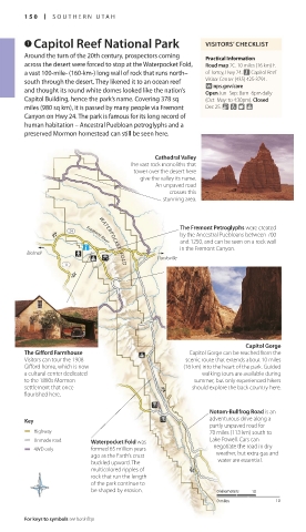
7 Capitol Reef National Park VISITORS’ CHECKLIST 8 Boulder Beyond Boulder, Hwy 12 climbs
to the 9,400-ft (2,865-m)
Around the turn of the 20th century, prospectors coming Practical Information Road map C2. n Anasazi State Park summit of Boulder Mountain.
across the desert were forced to stop at the Waterpocket Fold, Road map 2C. 10 miles (16 km) E. Museum (435) 335-7308. Open Mar–
Oct: 8am–6pm daily; Nov–Feb:
a vast 100-mile- (160-km-) long wall of rock that runs north– of Torrey, Hwy 24. n Capitol Reef 8am–4pm daily. 9 Burr Trail
south through the desert. They likened it to an ocean reef Visitor Center (435) 425-3791.
∑ nps.gov/care
and thought its round white domes looked like the nation’s Open Jun–Sep: 8am–6pm daily The tiny town of Boulder nestles Road map C2. n 755 W. Main St.,
Capitol Building, hence the park’s name. Covering 378 sq (Oct–May: to 4:30pm). Closed picturesquely among the Escalante (435) 826-5499. Open Mar–
surrounding peaks. The town is
Oct: 7:30am–5:30pm daily; Oct–Thanks-
miles (980 sq km), it is passed by many people via Fremont Dec 25. & 7 8 home to the Anasazi State Park, giving: 8am–4:30pm daily; late-Nov–
Canyon on Hwy 24. The park is famous for its long record of which offers restored ruins and Mar: 8am–4:30pm Mon–Fri.
human habitation – Ancestral Puebloan petroglyphs and a a museum detailing the history
preserved Mormon homestead can still be seen here. of the Ancestral Puebloans, who The Burr Trail is another partly
lived here between AD 1050 paved scenic road, winding
and 1200. Before Hwy 12 was through the Grand Staircase–
built, Boulder was virtually Escalante National Monument.
Cathedral Valley
The vast rock monoliths that isolated as the last town in The first 40 miles (65 km) are Lake Powell as seen from the end of
tower over the desert here America to receive its mail by paved and follow Deer Creek, Hole-in-the-Rock Road
give the valley its name. pack mule. Today, it makes a rising through the winding red-
An unpaved road welcome rest stop along Hwy rock maze of Long Canyon. At the (610-m-) deep abyss of Glen
crosses this 12, which connects Hwy 89 and canyon end, the view opens out Canyon. Undeterred, they dynamited
stunning area. Capitol Reef National Park. This to reveal the pristine valleys of the a narrow hole through a wall of
road boasts what may be the Circle Cliffs and Capitol Reef. The rock and constructed a primitive
most spectacular and diverse trail crosses Capitol Reef as an road down the sheer sides of the
array of landscapes found along unpaved road before reaching canyon. Lowering their wagons
The Fremont Petroglyphs were created any road in the country. Bullfrog Marina at Lake Powell (see and cattle down the path by
J Fremont River by the Ancestral Puebloans between 700 Between Escalante and pp154–5) and is passable only by ropes they finally reached the
and 1250, and can be seen on a rock wall Boulder, Hwy 12 winds through four-wheel-drive, high-clearance bottom, only to repeat the whole
in the Fremont Canyon. an unforgettable landscape of vehicles in dry weather. process in reverse to ascend the
Bicknell
Hanksville vividly colored, towering rock far side. They finally founded the
formations and twisting town of Bluff in 1880 (see p176).
WATERPOCKET FOLD
canyons. Visitors can stop at 0 Hole-in-the- Today, their original route, Hole-
Calf Creek Campground to hike Rock Road in-the-Rock Road, offers an
J
the 6-mile (10-km) round-trip impressive trip through the wild
trail to Lower Calf Creek Falls. Road map C2. n 755 W. Main St., interior of the Grand Staircase–
The falls are one of the hidden Escalante (435) 826-5499. Open Mar– Escalante National Monument.
treasures of the Southwest, a Oct: 7:30am–5:30pm daily; Oct–Thanks- About 18 miles (29 km) along the
126-ft (38-m) plume that drops giving: 8am–4:30pm daily; late-Nov– road, intrepid hikers can explore
past lush hanging gardens into Mar: 8am–4:30pm Mon–Fri. Peekaboo and Spooky canyons,
an emerald-green pool. two slot canyons barely one foot
Continuing along Hwy 12, just In 1879 a determined group of (30 cm) wide in places. A 4WD is
Capitol Gorge before Boulder, the road offers 230 Mormon settlers headed out necessary to traverse the last 6
The Gifford Farmhouse Capitol Gorge can be reached from the white-knuckle excitement, as it from Panguitch, hoping to create miles (10 km) to the pioneers’
Visitors can tour the 1908 scenic route that extends about 10 miles traverses the Hogsback, a knife- a new settlement in south eastern “Hole in the Rock,” a 50-ft (15-m)
Gifford home, which is now (16 km) into the heart of the park. Guided edge ridge of rock with guardrails Utah. Instead they were brought slit in the rock which offers a fine
a cultural center dedicated walking tours are available during and steep drops on either side. to a halt by the yawning 2,000-ft- view of Lake Powell.
to the 1880s Mormon summer, but only experienced hikers
settlement that once J should explore the back country here.
flourished here.
Notom-Bullfrog Road is an
Key adventurous drive along a
partly unpaved road for
Highway 70 miles (113 km) south to
Unmade road Waterpocket Fold was Lake Powell. Cars can
4WD only formed 65 million years negotiate the road in dry
weather, but extra gas and
ago as the Earth’s crust water are essential.
buckled upward. The
multicolored ripples of J
rock that run the length
of the park continue to
be shaped by erosion. 0 kilometers 10
0 miles 10
Hell’s Backbone Bridge, with steep mountain drops on either side, west of the town of Boulder
For keys to symbols see back flap For hotels and restaurants see pp240–41 and pp254–6
150-151_EW_SW_USA.indd 150 28/11/17 12:41 PM 150-151_EW_SW_USA.indd 151 28/11/17 12:41 PM
Eyewitness Travel LAYERS PRINTED:
Catalogue template “UK” LAYER
(Source v2.6)
Date 12th July 2013
Size 125mm x 217mm