
Page 153 - (DK Eyewitness) Travel Guide - Southwest USA & National Parks
P. 153
SOUTHERN UT AH 151
8 Boulder Beyond Boulder, Hwy 12 climbs
to the 9,400-ft (2,865-m)
Road map C2. n Anasazi State Park
Museum (435) 335-7308. Open Mar– summit of Boulder Mountain.
Oct: 8am–6pm daily; Nov–Feb:
8am–4pm daily. 9 Burr Trail
The tiny town of Boulder nestles Road map C2. n 755 W. Main St.,
picturesquely among the Escalante (435) 826-5499. Open Mar–
surrounding peaks. The town is Oct: 7:30am–5:30pm daily; Oct–Thanks-
home to the Anasazi State Park, giving: 8am–4:30pm daily; late-Nov–
which offers restored ruins and Mar: 8am–4:30pm Mon–Fri.
a museum detailing the history
of the Ancestral Puebloans, who The Burr Trail is another partly
lived here between AD 1050 paved scenic road, winding
and 1200. Before Hwy 12 was through the Grand Staircase–
built, Boulder was virtually Escalante National Monument.
isolated as the last town in The first 40 miles (65 km) are Lake Powell as seen from the end of
America to receive its mail by paved and follow Deer Creek, Hole-in-the-Rock Road
pack mule. Today, it makes a rising through the winding red-
welcome rest stop along Hwy rock maze of Long Canyon. At the (610-m-) deep abyss of Glen
12, which connects Hwy 89 and canyon end, the view opens out Canyon. Undeterred, they dynamited
Capitol Reef National Park. This to reveal the pristine valleys of the a narrow hole through a wall of
road boasts what may be the Circle Cliffs and Capitol Reef. The rock and constructed a primitive
most spectacular and diverse trail crosses Capitol Reef as an road down the sheer sides of the
array of landscapes found along unpaved road before reaching canyon. Lowering their wagons
any road in the country. Bullfrog Marina at Lake Powell (see and cattle down the path by
Between Escalante and pp154–5) and is passable only by ropes they finally reached the
Boulder, Hwy 12 winds through four-wheel-drive, high-clearance bottom, only to repeat the whole
an unforgettable landscape of vehicles in dry weather. process in reverse to ascend the
vividly colored, towering rock far side. They finally founded the
formations and twisting town of Bluff in 1880 (see p176).
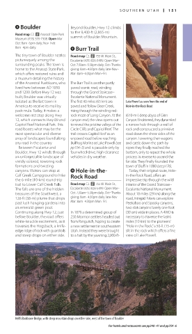
canyons. Visitors can stop at 0 Hole-in-the- Today, their original route, Hole-
Calf Creek Campground to hike Rock Road in-the-Rock Road, offers an
the 6-mile (10-km) round-trip impressive trip through the wild
trail to Lower Calf Creek Falls. Road map C2. n 755 W. Main St., interior of the Grand Staircase–
The falls are one of the hidden Escalante (435) 826-5499. Open Mar– Escalante National Monument.
treasures of the Southwest, a Oct: 7:30am–5:30pm daily; Oct–Thanks- About 18 miles (29 km) along the
126-ft (38-m) plume that drops giving: 8am–4:30pm daily; late-Nov– road, intrepid hikers can explore
past lush hanging gardens into Mar: 8am–4:30pm Mon–Fri. Peekaboo and Spooky canyons,
an emerald-green pool. two slot canyons barely one foot
Continuing along Hwy 12, just In 1879 a determined group of (30 cm) wide in places. A 4WD is
before Boulder, the road offers 230 Mormon settlers headed out necessary to traverse the last 6
white-knuckle excitement, as it from Panguitch, hoping to create miles (10 km) to the pioneers’
traverses the Hogsback, a knife- a new settlement in south eastern “Hole in the Rock,” a 50-ft (15-m)
edge ridge of rock with guardrails Utah. Instead they were brought slit in the rock which offers a fine
and steep drops on either side. to a halt by the yawning 2,000-ft- view of Lake Powell.
Hell’s Backbone Bridge, with steep mountain drops on either side, west of the town of Boulder
For hotels and restaurants see pp240–41 and pp254–6
150-151_EW_SW_USA.indd 151 28/11/17 12:41 PM