
Page 174 - (DK Eyewitness) Travel Guide - Southwest USA & National Parks
P. 174
172 THE FOUR C ORNERS THE FOUR C ORNERS 173
7 Canyon de Chelly National Monument Canyon Landscape VISITORS’ CHECKLIST
The sandstone cliffs of
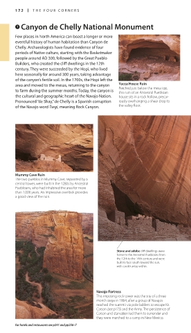
Few places in North America can boast a longer or more Canyon de Chelly reach Practical Information
as high as 1,000 ft
eventful history of human habitation than Canyon de (300 m), towering above Road map 3. Two miles (3.5 km)
Chelly. Archaeologists have found evidence of four the neighboring meadows east of Chinle and I-191. n P. O.
Box 588, Chinle (928) 674-5500.
periods of Native culture, starting with the Basketmaker and desert landscape in Open 8am–5pm daily. Closed
people around AD 300, followed by the Great Pueblo the distance. The canyon Thanksgiving, Dec 25, Jan 1. 7
Builders, who created the cliff dwellings in the 12th floor around the cliffs is partial. 8 obligatory (except
fringed with cotton
century. They were succeeded by the Hopi, who lived wood bushes, watered White House) – fee for tours.
0 = ∑ nps.gov/cach
here seasonally for around 300 years, taking advantage by the Chinle Wash.
of the canyon’s fertile soil. In the 1700s, the Hopi left the
area and moved to the mesas, returning to the canyon Yucca House Ruin
Perched just below the mesa top,
to farm during the summer months. Today, the canyon is this ruin of an Ancestral Puebloan
the cultural and geographic heart of the Navajo Nation. house sits in a rock hollow, precar- The pale walls of the
Pronounced “de Shay,” de Chelly is a Spanish corruption iously overhanging a sheer drop to White House cliff drop 550 ft
of the Navajo word Tsegi, meaning Rock Canyon. the valley floor. (168 m) to the canyon floor.
Hogan Interior
Made of horizontal
logs, the hogan is the
center of Navajo family
life. A smoke hole in
the center provides a
link with the sky,
while the dirt floor
gives contact with
Mummy Cave Ruin the earth. A door
The two pueblos in Mummy Cave, separated by a faces east to greet
central tower, were built in the 1280s by Ancestral the rising sun.
Puebloans, who had inhabited the area for more
than 1,000 years. An impressive overlook provides
a good view of the ruin.
White House Ruins
This group of rooms, tucked into a tiny hollow in the
cliff, seems barely touched by time. The dwellings
were originally situated above a larger pueblo, much
of which has now disappeared. It is the only site
within the canyon that can be visited without a
Navajo guide, and is reached via a steep 2.5-mile
(5-km) round-trip trail that winds to the canyon floor
and offers magnificent views.
Stone and adobe cliff dwellings were
home to the Ancestral Puebloans from Massacre Cave
the 12th to the 14th century and were
built to face south toward the sun, The canyon’s darkest hour was in 1805, when a Spanish force
with cooler areas within. under Lieutenant Antonio Narbona entered the area. The Spanish
wanted to subdue the Navajo, claiming they were raiding their
settlements. While some Navajo fled by climbing to the canyon
rim, others took refuge in a cave high in the cliffs. The Spanish
fired into the cave, and Narbona boasted that he had killed 115
Navajo, including 90 warriors. Navajo accounts are different,
Navajo Fortress claiming that most of the warriors were absent (probably
This imposing rock tower was the site of a three- hunting), and those killed were mostly women, children, and the
month siege in 1864, after a group of Navajos elderly. The only Spanish fatality came when a Spaniard attempting
reached the summit via pole ladders to escape Kit to climb into the cave was attacked by a Navajo woman and both
Carson (see p175) and the Army. The persistence of plunged over the cliff, gaining the Navajo name “Two Fell Over.” Pictograph on a canyon wall showing invading
Carson and starvation led them to surrender and The Anglo name is “Massacre Cave.” Spanish soldiers
they were marched to a camp in New Mexico.
For hotels and restaurants see p241 and pp256–7
172-173_EW_SW_USA.indd 172 28/11/17 12:41 PM 172-173_EW_SW_USA.indd 173 28/11/17 12:41 PM