
Page 181 - (DK Eyewitness) Travel Guide - Southwest USA & National Parks
P. 181
THE FOUR C ORNERS 179
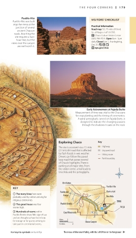
Pueblo Alto
Pueblo Alto was built VISITORS’ CHECKLIST
atop the mesa at the
junction of several Practical Information
ancient Chacoan Road map 3D. 25 miles (40 km)
roads. Reaching the S.E. of Nageezi off US 550.
n Chaco Culture Visitor Center
site requires a two-
hour hike, but the (505) 786-7014. Open 8am–5pm
views over the canyon daily. Closed Jan 1, Thanksgiving,
are well worth it. Dec 25. & 7 8
∑ nps.gov/chcu
Early Astronomers at Fajada Butte
Measurement of time was vital to the Chacoans
for crop planting and the timing of ceremonies.
A spiral petroglyph, carved on Fajada Butte, is
designed to indicate the changing seasons
through the shadows it casts on the rock.
Exploring Chaco Key
The site is accessed via a 13-mile Highway
(21-km) dirt road that is affected Unpaved road
by flash floods in wet weather. Hiking route
Drivers can follow the paved Park boundary
loop road that passes several
of Chaco’s highlights. There is
parking at all major sites. From
the visitor center, a trail leads to
Una Vida and the petroglyphs.
Kin Kletso
Pueblo Alto
KEY
Pueblo del Chetro Ketl
1 The many kivas here were Arroyo
probably used by visitors arriving for Una Vida
religious ceremonies.
2 This great house was four Pueblo Bonito
stories high. Wijiji
3 Hundreds of rooms within Casa Rinconada
Pueblo Bonito show little sign of use
and are thought to have been kept
for storage or for guests arriving to 0 km 2 Chaco Canyon
take part in ceremonial events. 0 miles 2
For keys to symbols see back flap The mesas of Monument Valley, with the Left Mitten in the foreground
178-179_EW_SW_USA.indd 179 28/11/17 12:41 PM