
Page 66 - (DK Eyewitness) Travel Guide - Southwest USA & National Parks
P. 66
64 ARIZ ONA GR AND C AN Y ON 65
1 Grand Canyon North Rim VISITORS’ CHECKLIST
The North Rim receives
The Grand Canyon is one of the world’s great natural wonders roughly one tenth the Practical Information
and an instantly recognizable symbol of the Southwest. The number of visitors of the Road map B3. n Visitor Center,
South Rim. While less
Mather Point, AZ (928) 638-7888.
canyon runs through Grand Canyon National Park (see pp64–7), accessible, it is a more Open South Rim: year round daily.
and is 277 miles (446 km) long, an average of 10 miles (16 km) peaceful destin ation, North Rim: summer only. Mule
wide, and around 5,000 ft (1,500 m) deep. It was formed over a offering a sense of rides: South Rim: book in advance
period of six million years by the Colorado River, whose fast- unexplored wilderness. (303) 297-2757; North Rim: register
It has a range of hikes,
at Grand Canyon Lodge (435) 679-
flowing waters sliced their way through the Colorado Plateau such as the North Kaibab 8665. Closed North Rim facilities:
(see pp22–3), which includes the gorge and most of northern Trail, a steep descent down mid-Oct–mid-May; road closed by
Arizona and the Four Corners region. The plateau’s geological to Phantom Ranch on the snow in winter. & 7 partial.
vagaries have defined the river’s twisted course and exposed canyon floor (see p64). 8 - = 0 ∑ nps.gov/grca
vast cliffs and pinnacles that are ringed by rocks of different Transport
color, variegated hues of limestone, sandstone, and shale k Grand Canyon Airport,
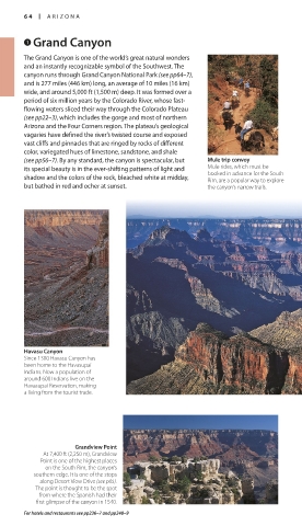
(see pp56–7). By any standard, the canyon is spectacular, but Mule trip convoy Tusayan. £ Grand Canyon
Railway from Williams daily.
its special beauty is in the ever-shifting patterns of light and Mule rides, which must be @ From Flagstaff and Williams.
booked in advance for the South
shadow and the colors of the rock, bleached white at midday, Rim, are a popular way to explore
but bathed in red and ocher at sunset. the canyon’s narrow trails.
View from Hopi Point
Projecting far into the canyon, the tip of Hopi Point
offers one of the best sunset-watching spots along
Hermit Road. As the sun sets, it highlights the
canyon’s beautiful sculpted peaks.
Yavapai Point at the South Rim
Havasu Canyon
Since 1300 Havasu Canyon has Situated 5 miles (8 km) north of the canyon’s
been home to the Havasupai South Entrance, along a stretch of the Rim
Indians. Now a population of Trail, is Yavapai Point. Its observation station
around 600 Indians live on the offers spectacular views of the canyon, and a
Havasupai Reservation, making viewing panel identifies several of the central
a living from the tourist trade. canyon’s landmarks.
Grandview Point Bright Angel Trail
At 7,400 ft (2,250 m), Grandview Used by both Native Americans and
Point is one of the highest places early settlers, the Bright Angel Trail
on the South Rim, the canyon’s follows a natural route along one
southern edge. It is one of the stops of the canyon’s enormous fault lines.
along Desert View Drive (see p65). It is an appealing option for day-hikers,
The point is thought to be the spot because, unlike some other trails in the
from where the Spanish had their area, it offers some shade and several
first glimpse of the canyon in 1540. seasonal water sources.
For hotels and restaurants see pp236–7 and pp248–9
064-065_EW_SW_USA.indd 64 28/11/17 12:39 PM 064-065_EW_SW_USA.indd 65 28/11/17 12:39 PM