
Page 70 - (DK Eyewitness) Travel Guide - Southwest USA & National Parks
P. 70
68 ARIZ ONA GR AND C AN Y ON 69
Exploring Grand Canyon National Park California Condors
Grand Canyon offers awe-inspiring beauty on a vast scale. The The Village is not only the The California Condor is America’s largest bird, with a wingspan
magnificent rock formations with towers, cliffs, steep walls, starting point for most of the of over 9 ft (2.7 m). The species was almost extinct in the 1980s,
and buttes recede as far as the eye can see, their bands of mule trips through the canyon, when the last 22 condors were captured for breeding
in captivity. In 1996 the first captivebred birds
colored rock varying in shade, as light changes through the but also the terminus for the were released in Northern Arizona. Today,
Grand Canyon Railway.
day. The park’s main roads, Hermit Road and Desert View Drive, over 80 condors fly the skies over Northern
both accessible from the south entrance, overlook the canyon. The South Rim Arizona. They are frequent visitors to
Grand Canyon Village is located on the South Rim and offers Most of the Grand Canyon’s 4.4 the South Rim, though visitors should
not approach or feed them.
a full range of facilities. Visitors can also enter the park from million annual visitors come to
the north, although this route (Hwy 67) is closed during the South Rim, since, unlike the A pair of California condors
North Rim, it is open year-round
winter. Walking trails along the North and South rims offer and is easily accessible along
staggering views, but to experience the canyon at its most Highway 180/64 from Flagstaff
fascinating the trails that head down toward the canyon floor or Williams. Hermit Road is is blocked by snow for most The Bright Angel Trail
should be explored. The Bright Angel Trail on the South Rim, closed to private vehicles from of the winter. The North Rim is This is the most popular of
and the North Kaibab Trail on the North Rim, descend to the March to November each year, Desert View’s stone Watchtower on Desert twice as far from the river as the all Grand Canyon hiking trails.
canyon floor, and are tough hikes involving an overnight stop. but there are free shuttle buses. View Drive South Rim, and the canyon The Bright Angel trailhead is
Desert View Drive (Hwy 64) really stretches out from the at Grand Canyon Village on
is open all year, winter snows Point from where it is possible overlooks giving a sense of its the South Rim. The trail begins
permitting. Both roads start to see Phantom Ranch (see p236). 10mile (16km) width. There near the Kolb Studio at the
at Grand Canyon Village and This is the only roofed accommo are about 30 miles (48 km) of western end of Grand Canyon
encompass a selection of the dation available on the canyon scenic roads along the North Village. It then switches
choicest views of the gorge. From floor, across the Colorado River. Rim as well as hiking trails to dramatically down the side of
Grand Canyon Village, Hermit The longer Desert View Drive high viewpoints or down to the the canyon for 9 miles (14 km).
Road extends 8 miles (13 km) to winds for 12 miles (20 km) to canyon floor (particularly the The trail crosses the river over
Hermits Rest and, in the opposite Grandview Point, where the North Kaibab Trail that links to a suspension bridge, ending
direction, Desert View Drive takes Spaniards may have had their the South Rim’s Bright Angel Trail.) a little further on at Phantom
26 miles (42 km) to reach the first glimpse of the canyon in The picturesque Cape Royal Ranch. There are two resthouses
stunning Desert View overlook, 1540. Ten miles (16 km) farther Drive starts north of Grand and a fully equipped
and then continues another 34 on lie the pueblo remains of Canyon Lodge and campground along the
miles (55 km) west to Cameron. Tusayan Ruin, where there is travels 23 miles (37 way. Do not attempt
Beginning at Grand Canyon a small museum featuring km) to Cape Royal on to walk all the way
Village, Hermit Road meanders exhibits on Ancestral Puebloan the Walhalla Plateau. to the river and back
along the South Rim, its first life. After a few miles, the road From here, several in one day. Many
viewpoint being Trailview leads to Desert View where the famous buttes and walk from the South
Overlook, which provides an Watchtower was Colter’s most peaks can be seen, Mule deer on the canyon’s Rim to one of the
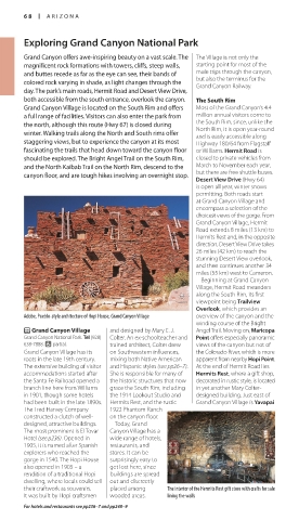
Adobe, Pueblo-style architecture of Hopi House, Grand Canyon Village overview of the canyon and the fanciful creation, its upper including Wotans North Rim rest stops and then
winding course of the Bright floor decorated with early Throne and Vishnu return up to the rim.
P Grand Canyon Village and designed by Mary E. J. Angel Trail. Moving on, Maricopa 20thcentury Hopi murals. Temple. There are also several Temperatures at the bottom
Grand Canyon National Park. Tel (928) Colter. An ex-schoolteacher and Point offers especi ally panoramic short, easy walking trails around of the canyon can reach 110°F
638-7888. 7 partial. trained architect, Colter drew views of the canyon but not of The North Rim Cape Royal, both along the (43°C) or higher during the
Grand Canyon Village has its on Southwestern influences, the Colorado River, which is more Standing at about 8,000 ft top. A 3mile (5km) detour summer. It is essential for day
roots in the late 19th century. mixing both Native American apparent from nearby Hopi Point. (2,400 m), the North Rim is leads to Point Imperial, the hikers to carry a quart (just
The extensive building of visitor and Hispanic styles (see pp26–7). At the end of Hermit Road lies higher, cooler, and greener highest point on the canyon over a liter) of water per person
accommodations started after She is responsible for many of Hermits Rest, where a gift shop, than the South Rim, with dense rim, while along the way the per hour for summer hiking,
the Santa Fe Railroad opened a the historic structures that now decorated in rustic style, is located forests of ponderosa pine, aspen, Vista Encantada has delightful as well as plenty of salty
branch line here from Williams grace the South Rim, including in yet another Mary Colter- and Douglas fir. Visitors are likely views and picnic tables over snacks. Carrying a firstaid
in 1901, though some hotels the 1914 Lookout Studio and designed building. Just east of to spot wildlife on the North looking the gorge. kit is also recommended.
had been built in the late 1890s. Hermits Rest, and the rustic Grand Canyon Village is Yavapai Rim. Mule deer, Kaibab squirrel,
The Fred Harvey Company 1922 Phantom Ranch and wild turkey are among the
constructed a clutch of well- on the canyon floor. most common sights. The North
designed, attractive buildings. Today, Grand Rim is reached via Highway 67,
The most prominent is El Tovar Canyon Village has a off Highway 89A, ending at
Hotel (see p236). Opened in wide range of hotels, Grand Canyon Lodge (see
1905, it is named after Spanish restaurants, and pp236 and 248) where there are
explorers who reached the stores. It can be visitor services, a campground,
gorge in 1540. The Hopi House surprisingly easy to gas station, restaurant, and a
also opened in 1905 – a get lost here, since general store. Nearby, the North
rendition of a traditional Hopi buildings are spread Rim Visitor Center offers maps of
dwelling, where locals could sell out and discreetly the area. Facilities on the North
their craftwork as souvenirs. placed among The interior of the Hermits Rest gift store with crafts for sale Rim are closed midOctober–
It was built by Hopi craftsmen wooded areas. lining the walls midMay, while the road access Visitors at the trailhead of the Bright Angel Trail
For hotels and restaurants see pp236–7 and pp248–9
068-069_EW_SW_USA.indd 68 28/11/17 12:39 PM 068-069_EW_SW_USA.indd 69 11/01/2018 11:59
Eyewitness Travel LAYERS PRINTED:
Catalogue template “UK” LAYER
(Source v2.6)
Date 12th July 2013
Size 125mm x 217mm