
Page 194 - (DK Eyewitness) Travel Guide 2017 - Alaska
P. 194
192 ALASK A AREA B Y AREA
9 Wrangell-St. Elias National Park
Wrangell-St. Elias National Park, the largest national ALASKA
park in the US – six times the size of Yellowstone – is Glennallen
a 20,000 sq mile (52,500 sq km) wilderness sprawling • Area of the map
across the southeast corner of the Alaskan mainland. illustrated CANADA
Dominated by the volcanic Wrangell Mountains and McCarthy •
the glaciated St. Elias Range, the park has nine of the
16 highest mountains in the US. Designated a UNESCO
World Heritage Site in 1992, the park contains remnants
of historic mining sites and harbors a wealth of wildlife. Gulf of Alaska
Major activities include hiking, whitewater rafting, and
taking flightseeing tours over the park’s vast expanses. Locator Map
Wrangell-St. Elias National Park
G L E N N H W Y Chistochina Copper N A B E S N A R O A D
T O K C U T - O F F
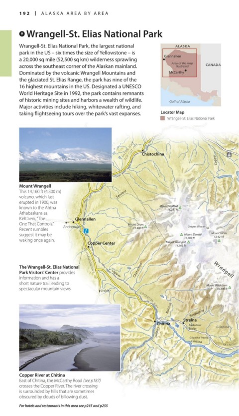
Mount Wrangell
This 14,160 ft (4,300 m) Sanford
volcano, which last
erupted in 1900, was
known to the Ahtna Mount Sanford
16,237 ft
Athabaskans as
K’elt’aeni, “The Glennallen
One That Controls.” Anchorage Mount Drum
Recent rumbles 12,400 ft Copper Glacier
suggest it may be Mount Zanetti Mount Jarvis
13,421 ft
waking once again. 13,009 ft
Copper Center Mount Wrangell
14,163 ft Nabesna Glacier
The Wrangell-St. Elias National RICHARDSON HWY
Park Visitors’ Center provides Copper Chetaslina
information and has a
short nature trail leading to Mount Blackburn
spec tacular mountain views. 16,390 ft
Valdez
Wrangell Mountains
Kotsina Kuskulana
EDGERTON HWY
Strelna Root Glacier
Chitina Kuskulana Kennicott Glacier
Bridge Gilahina
Gilahina Trestle
Copper
MCCARTHY ROAD
Chitina
Copper River at Chitina Chakina
East of Chitina, the McCarthy Road (see p187)
crosses the Copper River. The river crossing
is surrounded by hills that are sometimes
obscured by clouds of billowing dust.
For hotels and restaurants in this area see p245 and p255
192-193_EW_Alaska.indd 192 02/05/17 2:31 pm