
Page 198 - (DK Eyewitness) Travel Guide 2017 - Alaska
P. 198
196 ALASK A AREA B Y AREA
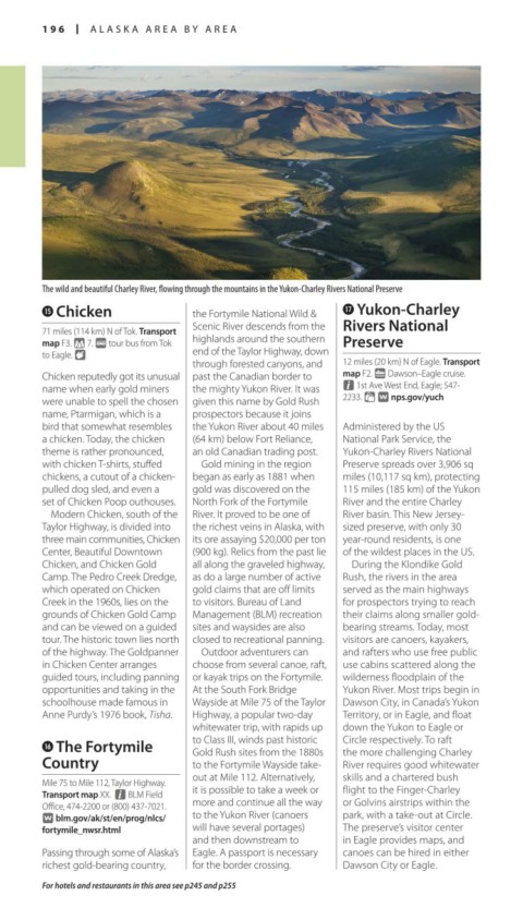
The wild and beautiful Charley River, flowing through the mountains in the Yukon-Charley Rivers National Preserve
t Chicken the Fortymile National Wild & u Yukon-Charley
Scenic River descends from the Rivers National
71 miles (114 km) N of Tok. Transport
map F3. * 7. @ tour bus from Tok highlands around the southern Preserve
to Eagle. 8 end of the Taylor Highway, down
through forested canyons, and 12 miles (20 km) N of Eagle. Transport
Chicken reputedly got its unusual past the Canadian border to map F2. g Dawson–Eagle cruise.
name when early gold miners the mighty Yukon River. It was n 1st Ave West End, Eagle; 547-
were unable to spell the chosen given this name by Gold Rush 2233. = ∑ nps.gov/yuch
name, Ptarmigan, which is a prospectors because it joins
bird that somewhat resembles the Yukon River about 40 miles Administered by the US
a chicken. Today, the chicken (64 km) below Fort Reliance, National Park Service, the
theme is rather pronounced, an old Canadian trading post. Yukon-Charley Rivers National
with chicken T-shirts, stuffed Gold mining in the region Preserve spreads over 3,906 sq
chickens, a cutout of a chicken- began as early as 1881 when miles (10,117 sq km), protecting
pulled dog sled, and even a gold was discovered on the 115 miles (185 km) of the Yukon
set of Chicken Poop outhouses. North Fork of the Fortymile River and the entire Charley
Modern Chicken, south of the River. It proved to be one of River basin. This New Jersey-
Taylor Highway, is divided into the richest veins in Alaska, with sized preserve, with only 30
three main com munities, Chicken its ore assaying $20,000 per ton year-round residents, is one
Center, Beautiful Downtown (900 kg). Relics from the past lie of the wildest places in the US.
Chicken, and Chicken Gold all along the graveled highway, During the Klondike Gold
Camp. The Pedro Creek Dredge, as do a large number of active Rush, the rivers in the area
which operated on Chicken gold claims that are off limits served as the main highways
Creek in the 1960s, lies on the to visitors. Bureau of Land for prospectors trying to reach
grounds of Chicken Gold Camp Management (BLM) recreation their claims along smaller gold-
and can be viewed on a guided sites and waysides are also bearing streams. Today, most
tour. The historic town lies north closed to recreational panning. visitors are canoers, kayakers,
of the highway. The Goldpanner Outdoor adventurers can and rafters who use free public
in Chicken Center arranges choose from several canoe, raft, use cabins scattered along the
guided tours, including panning or kayak trips on the Fortymile. wilderness floodplain of the
opportunities and taking in the At the South Fork Bridge Yukon River. Most trips begin in
school house made famous in Wayside at Mile 75 of the Taylor Dawson City, in Canada’s Yukon
Anne Purdy’s 1976 book, Tisha. Highway, a popular two-day Territory, or in Eagle, and float
whitewater trip, with rapids up down the Yukon to Eagle or
y The Fortymile to Class III, winds past historic Circle res pectively. To raft
Gold Rush sites from the 1880s
the more challeng ing Charley
Country to the Fortymile Wayside take- River requires good whitewater
out at Mile 112. Alternatively, skills and a chartered bush
Mile 75 to Mile 112, Taylor Highway.
Transport map XX. n BLM Field it is possible to take a week or flight to the Finger-Charley
Office, 474-2200 or (800) 437-7021. more and continue all the way or Golvins airstrips within the
∑ blm.gov/ak/st/en/prog/nlcs/ to the Yukon River (canoers park, with a take-out at Circle.
fortymile_nwsr.html will have several portages) The preserve’s visitor center
and then downstream to in Eagle provides maps, and
Passing through some of Alaska’s Eagle. A passport is necessary canoes can be hired in either
richest gold-bearing country, for the border crossing. Dawson City or Eagle.
For hotels and restaurants in this area see p245 and p255
196-197_EW_Alaska.indd 196 02/05/17 2:31 pm