
Page 200 - (DK Eyewitness) Travel Guide 2017 - Alaska
P. 200
198 ALASK A AREA B Y AREA
o The Yukon River
Rising in the high peaks of northwestern British Columbia
in Canada and flowing 2,300 miles (3,680 km) across the ALASKA
Yukon Territory and Alaska to the Bering Sea, the Yukon River Yukon CANADA
provides a vital transport route for the people who live along Bering Anchorage • Fairbanks
Sea
it. Only four bridges cross the river – at Tagish, Whitehorse, •
and Carmacks in Canada, and at Mile 56 of Alaska’s Dalton Gulf of
Alaska
Highway. In the winter, the frozen river is a venue for a part PACIFIC OCEAN
of the Yukon Quest International Sled Dog Race, while in the Locator Map
summer, it offers adventure activities ranging from after noon Area illustrated
paddles and catamaran cruises to longer expedi tions from
the river’s headwaters to the Bering Sea.
Yukon
ALASKA Circle
DALTON
Central
HIGHWAY
Yukon-Charley
Livengood STEESE HIGHWAY Rivers National
ELLIOT HWY Preserve
Tanana
Manley Fairbanks
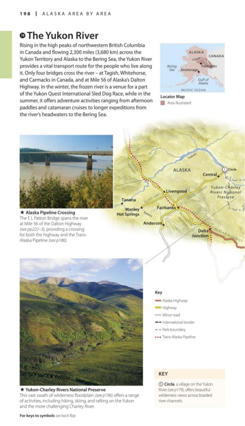
. Alaska Pipeline Crossing Hot Springs Tanana
The E L Patton Bridge spans the river RICHARDSON
at Mile 56 of the Dalton Highway Anderson HIGHWAY
(see pp222–3), providing a crossing Delta
for both the highway and the Trans- Junction A L A S K A H I G H W A Y TAYLOR HWY
Alaska Pipeline (see p186).
Tetlin
Junction
Key
Alaska Highway
Highway
Minor road
International border
Park boundary
Trans-Alaska Pipeline
KEY
1 Circle, a village on the Yukon
. Yukon-Charley Rivers National Preserve River (see p179), offers beautiful
This vast swath of wilderness floodplain (see p196) offers a range wilderness views across braided
of activities, including hiking, skiing, and rafting on the Yukon river channels.
and the more challenging Charley River.
For keys to symbols see back flap
198-199_EW_Alaska.indd 198 02/05/17 2:31 pm