
Page 9 - (DK) Ocean - The Definitive Visual Guide
P. 9
7
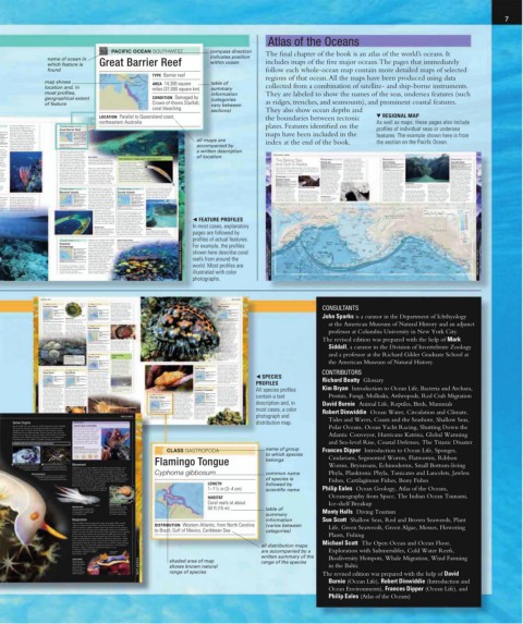
Atlas of the Oceans
PACIFIC OCEAN SOUTHWEST compass direction The final chapter of the book is an atlas of the world’s oceans. It
name of ocean in indicates position
which feature is Great Barrier Reef within ocean includes maps of the five major oceans. The pages that immediately
found follow each whole-ocean map contain more detailed maps of selected
TYPE Barrier reef
regions of that ocean. All the maps have been produced using data
map shows AREA 14,300 square table of
location and, in miles (37,000 square km) summary collected from a combination of satellite- and ship-borne instruments.
most profiles, information They are labeled to show the names of the seas, undersea features (such
geographical extent CONDITION Damaged by (categories
of feature Crown-of-thorns Starfish; vary between as ridges, trenches, and seamounts), and prominent coastal features.
coral bleaching
sections) They also show ocean depths and
LOCATION Parallel to Queensland coast, the boundaries between tectonic ▼ REGIONAL MAP
northeastern Australia 161 As well as maps, these pages also include
In 1988, the Philippines government PACIFIC OCEAN SOUTHWEST plates. Features identified on the
intervened, declaring the area a profiles of individual seas or undersea
National Marine Park, and since 1993 Great Barrier Reef
it has also been a UNESCO World
s Heritage Site. The condition of the TYPE Barrier reef
square km Tubbataha reefs has much improved, AREA 37,000 square km maps have been included in the features. The example shown here is from
e miles) due to the enforcement of measures (14,300 square miles)
Good; such as a prohibition on fishing and a CONDITION Damaged by
from coral ban on boats anchoring on the reefs tropical storms, pollution, all maps are
n 2010 (visiting craft must use mooring buoys). and an unbalanced index at the end of the book. the section on the Pacific Ocean.
he Philippines A setback occurred in January 2013 ecosystem
when a US Navy minesweeper ran LOCATION Parallel to Queensland coast, accompanied by
northeastern Australia
aground on the reef, damaging over
und two 2,000 square m (21,500 square ft).
u Sea and Australia’s Great Barrier Reef, which a written description
e pelagic stretches 2,010km (1,250 miles), is
attracted the world’s largest coral reef system. of location 458 THE PACIFIC OCEAN 459
nta Rays, Often described as the largest structure REEF CHANNEL
eeply ever made by living organisms, it in In this view of a central area of the reef, THE WORLD’S SMALLEST VERTEBRATE? PACIFIC OCEAN D3 for about half of the total US fish PACIFIC OCEAN I3 PACIFIC OCEAN L4
and shellfish catch. Harbor seals
ch in fact consists of some 3,000 individual a deep, meandering channel separates two The Bering Sea and gray whales also take advantage of
pecies reefs and small coral islands. Its outer reef platforms. The region’s high tidal range One of the tiniest residents of the Bering Sea these productive waters. In contrast to Gulf of Alaska Cascadia Basin
ibranchs edge ranges from 30 to 250km (18 to drives strong currents through such channels. Great Barrier Reef, at just And Gulf of Alaska AREA 890,000 square miles (2.3 million square km) the deep ocean basin beneath the AREA 600,000 sq. miles (1.5 million sq. km) AREA 66,000 sq. miles (170,000 sq. km)
0 species 155 miles) from the mainland, and its 7–8mm (less than 1 ⁄3in) long from MAXIMUM DEPTH 20,021 ft (6,102 m) southwestern half of the sea, the broad MAXIMUM DEPTH 16,400 ft (5,000 m) MAXIMUM DEPTH 9,600 ft (2,930 m)
continental shelf in the northwest
biological diversity is high. The reef However, a study published in 2012 snout to tail, is the Stout Infantfish. THE COLD, STORMY SUBPOLAR SEAS of the North Pacific are INFLOWS Pacific Ocean; Yukon, Anadyr’ rivers is very shallow. Much of this area INFLOWS Susitna, Copper rivers; icebergs from INFLOWS Pacific Ocean; Columbia, Fraser rivers
bbataha contains about 350 species of stony reported that the reef has lost more When discovered in 2004, the highly productive, supporting a rich fishery. Geologically, the area The Bering Sea is named after a formed a land bridge during the numerous glaciers The Cascadia Basin is the last remnant
vers coral and many of soft coral. Its 1,500 than half its coral cover since 1985. Infantfish was declared to be the is dominated by a subduction zone, and the area’s volcanoes and Danish navigator in the Russian last ice age, when sea levels were A counterclockwise subpolar gyre extends of the original eastern Pacific oceanic
in the species of fish range from 45 species of The factors causing this damage world’s smallest vertebrate species. That earthquakes pose an ever-present danger. Navy, who explored the area in up to 390 ft (120 m) lower than they across the north Pacific and into the plate, the Farallon Plate, which has
1980s butterflyfish, to several shark species, include pollution, tropical cyclones, title has since been claimed first by a slightly 1741. It lies between mainland Asia are today. This route was ice-free for Gulf of Alaska, fed by the warm waters been almost entirely subducted beneath
extended periods, allowing several
of the northern Kuroshio Extension,
and North America, and is bounded
North America. The Cascade Range
mage including silvertip, hammerhead, and raised water temperature causing mass smaller species of Indonesian cyprinid fish, and PACIFIC OCEAN by the Aleutian Islands to the south species, including humans, to migrate the extension of the Kuroshio Current. of volcanoes in Oregon and Washington
tices and whale sharks. The reef is also home to coral bleaching, population outbreaks more recently by a tiny species of frog, about Aleutian Trench and linked to the Arctic Ocean in from Asia to North America on foot The surface waters are cooled and State, including Mount St. Helens, are
ed farm. 500 species of algae, 20 species of sea of the Crown-of-thorns Starfish, 7mm ( 1 ⁄4in) long, found in Papua New Guinea. LENGTH 2,000 miles (3,200 km) the north by the narrow Bering for the first time. become less saline due to precipitation a product of this subduction. Mount
as they cross the ocean. Many of the
Strait. There is a flow of cold
St. Helens erupted in a catastrophic
snake, and 4,000 species of mollusc. overfishing, and shipping accidents.
MAXIMUM DEPTH 26,600 ft (8,100 m) Arctic water south through this storms that lash the west coast of ALASKAN FJORD explosion in 1982, killing 57 people,
strait, feeding a counterclockwise Canada originate in the Gulf of The valleys and fjords of the Alexander Fuca Plate west of Vancouver Island. and still shows signs of activity.
RATE OF CLOSURE 3 in (8 cm) per year
lving The Bering Sea is bounded to the SEALS IN THE ALEUTIAN ISLANDS circulation. The main freshwater Alaska. The circulation is completed as Archipelago testify to extensive erosion The seamounts were created above the Earthquakes and associated tsunamis
the Alaska Current and the Aleutian
hotspot over the last 30 million years,
input is the Yukon River, which
are also a risk in the area, although
by glaciers during the last ice age.
coral PACIFIC OCEAN SOUTHWEST The Marshall Islands consist of 29 PACIFIC OCEAN SOUTHWEST recorded. The reefs’ health is generally south by the Aleutian Islands. On has deposited an extensive delta Current return west along the Alaskan then carried northwest by seafloor the last major earthquake is thought
f coral atolls and five small islands in good, but some reefs around the busy the Pacific side of the islands lies the where the contact is between ocean at its mouth. The Bering Sea coast and south of the Aleutian Islands. were born. The floor of the Gulf of spreading. Since 1977, oil has been to have been in 1700. The underlying
Marshall Islands the western Pacific. The atolls lie on Society Islands holiday destination islands of Tahiti, Aleutian Trench, marking where the crust and continental crust. The largest is one of the world’s richest The gulf’s waters are very productive, Alaska is peppered with seamounts. shipped through ports on the south ocean crust appears to be split into
top of ancient volcanic peaks that are Moorea, and Bora-Bora have been Pacific Plate is plunging beneath volcanic event of the 20th century was fisheries, helping Alaska account providing feeding grounds for many There are two main chains: the Patton coast of Alaska. In 1989, Prince William three small plates. The largest is
TYPE Atolls thought to have erupted from the TYPE Fringing reefs, severely affected by construction, the North American Plate. It is this the eruption of Mount Katmai on THE BERING STRAIT species of fish. Pacific salmon spend and Gilbert seamounts, and the Kodiak Sound was the site of one of the worst the Juan de Fuca Plate, named after
up to five years at sea, much of it in
the Alaskan Peninsula in 1912. This
subduction zone that gives rise to
maritime environmental disasters, when
Seamounts, both running away from
a Greek sea captain who explored
diversity of Humphead Parrotfish, and various AREA 6,200 square km ocean floor 50-60 million years ago. barrier reefs, atolls sewage, and sediment run-off. the volcanic arc of islands, the most boundary can also produce powerful This satellite image shows ice from the gulf and adjacent seas, before the Alaska Peninsula. Their origin is the tanker Exxon Valdez ran aground, the area for Spain in 1592. The
r example, species of octopuses and nudibranchs (2,400 square miles) They include Kwajalein, the largest AREA 1,500 square km northerly link in the Pacific Ring of earthquakes such as the event that the Chukchi Sea streaming south returning to spawn in the Asian and the Cobb Hotspot, situated beneath releasing about 30 million gallons Explorer Plate lies to the north and
n more (sea slugs). Major threats to the reefs CONDITION Generally atoll in the Pacific at 2,500 square km (600 square miles) Fire. The trench continues to the east, destroyed part of Anchorage in 1964. through the Bering Strait. North American rivers where they the spreading center of the Juan de (114 million liters) of crude oil. the Gorda Plate to the south.
more than in Nusa Tenggara include pollution good; some episodes (1,000 square miles), and Bikini and CONDITION Good, but
mbined), from land-based sources, removal of of coral bleaching Enewetak atolls, which were used by significant local damage A B C D E F G H I J K L
reef- fish for the aquarium trade, and reef LOCATION Micronesia, southwest of Hawaii, the USA for testing nuclear weapons LOCATION French Polynesia, northeast of New
imals here destruction by blast fishing. Coral western Pacific between 1946 and 1962. Human Zealand, south-central Pacific 60˚N 150˚E 160˚E 170˚E 180˚ Arctic Circle 170˚W 160˚W 150˚W Arctic Circle 140˚W 130˚W 120˚W 110˚W
Bay
Rays, bleaching affected some reefs in 2010. pressures on these two Chukotskiy Chukchi Sea Goodhope SCALE KEY
remote, evacuated atolls have The Society Islands comprise a chain Anadyr’ Poluostrov 0 100 200 300 400 500 km sea level
been minimal during the of volcanic and coral islands in the 1 Anadyr’ Bering Strait Seward 1
past 50 years, and marine life South Pacific, including islands with RUSSIAN Gulf of Peninsula UNITED S T A TES 0 100 200 300 400 500 miles 800 ft (250 m)
around them now thrives; for barrier reefs (such as Rai’atea), islands FEDERA TION Anadyr Nome OF AMERICA 1,600 ft
example, 250 species of coral with both fringing and barrier reefs ◀ FEATURE PROFILES Mys Chukotskiy Chirikof Yukon River 60˚N (500 m) 3,300 ft
Basin
and up to 1,000 species of fish (such as Tahiti), and atolls or near- Sea of Okhotsk Khatyrka Norton Norton (1,000 m)
have been recorded at Bikini. atolls (such as Maupihaa and Maupiti). Saint Lawrence Plain Sound 6,500 ft (2,000 m)
The reefs’ biological diversity is Ossora 12m Mys Navarin 9,800 ft
MAJURO ATOLL moderate compared with the reefs In most cases, explanatory Karaginsky Zaliv Olyutorskiy (39ft) 29m Island Kuskokwim River (3,000 m)
Zaliv
(95ft)
As with many Pacific atolls, the rim of Southeast Asia, although more than MOOREA Ostrov Karaginskiy Mys Olyutorskiy 16,400 ft (5,000 m)
of Majuro Atoll consists partly of 160 coral species, 800 species of reef A wide fringing reef almost completely Hooper Anchorage CANAD A
shallow submerged reef and partly fish, 1,000 species of mollusc, and surrounds the shoreline of mountainous pages are followed by 2 Kamchatka Bay Cordova land 2
of small, low-lying islands. 30 species of echinoderm have been Moorea, part of which is visible in this view. Kamchatka Peninsula Kamchatka Mys Sivuchiy Basin Pervenets Saint Matthew Kenai Peninsula Seward Prince Cape Yakutat Juneau seamount
Island
Ust’-Kamchatsk
635m
Sound
maximum depth
on map
northwest over a hotspot in the Earth’s profiles of actual features. Kamchatskiy (2,083ft) S h i r s h o v R i d g e Canyon Nunivak Island Etolin Strait Cook Inlet Homer William Saint Elias Glacier Bay Chichagof Admiralty sea depth
PACIFIC OCEAN CENTRAL mantle. Coral reefs fringe some coastal FRENCH FRIGATE SHOALS Petropavlovsk- Kronotskiy Zaliv Ostrov Beringa Mednyy 20m Kuskokwim Portlock 295m (968ft) Gulf of Alaska Island Sitka Island tectonic plate
Bay
Reef fish, including Longfin Bannerfish,
Hawaiian areas of the younger, substantial islands Milletseed Butterflyfish, and For example, the profiles Kamchatskiy Mys Zaliv Kamchatka T errace 7,864m Seamount Aleutian Ber ing Sea (66ft) Cape Newenham Cape Shuyak Island Bank (11,943ft) Baranof Island Ketchikan boundary
3,640m
Basin
Komandorskiye
at the southeastern end of the chain,
Bluestripe Snappers,
Ostrova
Archipelago such as Oahu and Molokai. To the swim around Shipunskiy (25,802ft) Ostrov Mednyy (13,203ft) Pribilof Constantine Alaska Peninsula Shelikof Strait Kodiak Kodiak Gulf of Alaska Seamount Province Alexander Archipelago Prince of Wales Prince Rupert
4,024m
Pratt
Quinn
Bristol
Seamount
northwest, located on the submerged a table coral. 3 Bay Giacomini Seamount Island 3
6,102m
TYPE Fringing reefs, (20,021ft) Islands 20m (66ft) 62m Island Seamount Durgin Dixon
atolls, submerged reefs summits of older, sunken islands, are 50˚N Kurile Trench Obruchev Rise Bowers Ulm (203ft) Surveyor Seamount Kodiak Knox Cape Entrance
several near-atolls (such as the French shown here describe coral Seamount Plateau Seamount Dickins
Welker
AREA 1,180 square km 33m 11m Port Moller Seamount Seamounts Hecate Strait 213m
(450 square miles) Frigate Shoals) and atolls (such as (108ft) Attu Bowers Bowers (36ft) Denson (699ft) 50˚N
Midway Atoll). These reefs are highly Attu Bank Bowers Ridge Patton Alaska Plain Seamount Cape
CONDITION Coral disease OCEAN ENVIRONMENTS Island Near Basin Unimak Shumagin Seamount Patton Miller Seamount Queen Charlotte Islands St.James
Bowie
Islands
outbreaks reported isolated from all other coral reefs reefs from around the Agattu Islands Island False Seamounts Seamount Seamount QueenCharlotte
Umnak Bering Canyon
in the world, and although their Island Plateau Pass A l e u t i a n Tr e n ch Oshawa Sound
LOCATION North-central Pacific A l e u t i a n R i s e Takoma Seamount Seamount Cape Strait of Georgia Vancouver
Murray
overall biological diversity is Reef Umnak Dutch Davidson White Marsh Scott Vancouver Island
Gilbert
relatively low, many new species ATLAS OF THE OCEANS Northwest A l e u t i a n Tr e n ch Kiska Island Rat Islands Island A l e u t i a n I s l Island Harbor Unalaska Island Bank Seamount Seamount ATLAS OF THE OCEANS
Strait of Victoria
Atka
The Hawaiian Archipelago consists of have evolved on them. The world. Most profiles are 4 Pacific 1,857m Emperor Seamounts Amchitka Amchitka Pass Tanaga Island Atka Amukta Pass a n d s Fox Islands Parker Schoppe Ridge Explorer Juan de Fuca Seattle 4
the exposed peaks of a huge undersea more remote reefs are healthy, 160˚E Basin (6,093ft) Island Andreanof Islands Seamount Gibson G i l b e r t S e a m o u n t s Seamount UNITED
mountain range. These mountains have but in 2013, a serious coral Seamount Peters Ridge STATES OF
formed over tens of millions disease was reported affecting illustrated with color 6,088m 7,314m 5,267m 766m (2,513ft) Cascadia AMERICA
of years as the Pacific Plate moves reefs on Oahu and Kauai. (19,975ft) 170˚E 180˚ 170˚W (23,997ft) 160˚W (17,281ft) 150˚W 140˚W 130˚W Basin
photographs. A B C D E F G H I J K L
284 ANIMAL LIFE MOLLUSKS 285
Easily distinguished from most other
CLASS GASTROPODA orange foot CLASS GASTROPODA CLASS GASTROPODA
with gastropods by the conical shape of its
Common Limpet greenish Top Shell spiral shell, the top shell moves slowly Tiger Cowrie
tint
over reef flats and coral rubble, feeding CONSULTANTS
on algae. Demand for its flesh and
Patella vulgata Tectus niloticus Cypraea tigris
pretty shell has led to declining
DIAMETER LENGTH LENGTH
2 1 / 2 in (6 cm) 6 in (16 cm) numbers, especially in the Philippines, Up to 6 in (15 cm)
HABITAT due to unregulated harvesting. It has,
HABITAT HABITAT
Rocks on high shore to conical Intertidal and shallow however, been successfully introduced Low tide to 100 ft (30 m)
subtidal areas, reef flats
sublittoral zone shell elsewhere in the Indo-Pacific, such on coral reefs and flats John Sparks is a curator in the Department of Ichthyology
to 23 ft (7 m)
MUSCULAR FOOT as French Polynesia and the Cook
DISTRIBUTION Northeastern Atlantic from Arctic The common limpet’s muscular foot, seen here DISTRIBUTION Eastern Indian Ocean, western and Islands, from where some original sites DISTRIBUTION Indian Ocean, western Pacific
Circle to Portugal from below, holds it firmly to its rock, southern Pacific are being restocked. One of the largest cowrie species,
Abundant on rocks from the high regardless of the strength of the waves. the tiger cowrie has a shiny, smooth, at the American Museum of Natural History and an adjunct
to the low water mark, the common taller shells allow for better water CLASS GASTROPODA domed shell with a long, narrow
limpet is superbly adapted to shore retention during periods of exposure. aperture, and is variously mottled
life. A conical shell protects it from Limpets travel slowly during low tide, Red Abalone in black, brown, cream, and orange.
predators and the elements. Limpets covering up to 24 in (60 cm) using The cowrie’s mantle (its body’s outer,
living at the low water mark are contractions of their single foot. They Haliotis rufescens enclosing layer) can extend to professor at Columbia University in New York City.
buffeted by the waves and so require graze on algae from rocks using a LENGTH cover parts of the exterior of
smaller, flatter shells than those living radula (a rasplike structure), which has 6–8 in (15–20 cm) the shell. These extensions
at the high water mark, where wider, teeth reinforced with iron minerals. HABITAT have numerous projections,
Rocks from low tide or papillae, whose exact
mark to 100 ft (30 m)
function is unknown, but
which may increase the The revised edition was prepared with the help of Mark
DISTRIBUTION East Pacific coasts from southern three to five clearly visible holes in surface area for oxygen
absorption or provide
Oregon, US to Baja California, Mexico the shell, through which water flows camouflage of some sort. Tiger
for respiration.These are filled and
The largest of the abalone species, replaced with new holes as the cowries are nocturnal creatures,
the red abalone is so called because abalone increases in size. Sea otters hiding in crevices among the Siddall, a curator in the Division of Invertebrate Zoology
of the brick-red color of its thick, are one of the red abalone’s main coral during the day and emerging
roughly oval shell. There is an arc of predators, along with human divers. at night to graze on algae. The sexes
are separate and fertilization occurs
internally. Females exhibit some
CLASS GASTROPODA parental care in that they protect their and a professor at the Richard Gilder Graduate School at
egg capsules by covering them with
RETURNING HOME Venus Comb HIDING FROM their muscular foot until they hatch
Limpets gradually grind a “scar” into their VIEW into larvae, which then enter the
anchor spot on the rock, to aid their grip Murex pecten There are times when the Venus plankton to mature.
and help retain water. A mucus trail leads LENGTH comb buries itself just below the
them back to the spot. Up to 3 in (8 cm) the American Museum of Natural History.
surface of the sea floor, displacing
HABITAT the sand with movements of its
Tropical warm waters to muscular foot. However, it leaves CLASS GASTROPODA This gastropod is one of the very few
650 ft (200 m) animals that eats the crown-of-thorns
the opening of its tubular inhalant starfish, itself a voracious predator and
siphon above the sand’s surface so Giant Triton
CLASS GASTROPODA CLASS GASTROPODA DISTRIBUTION Eastern Indian Ocean and western that it can draw water into its destroyer of coral reefs. The giant
Pacific mantle cavity to obtain oxygen Charonia tritonis triton is an active hunter that will chase
Zebra Nerite Dog Whelk and to “taste” the water for the LENGTH prey, such as starfish, mollusks, and sea CONTRIBUTORS
The tropical carnivorous snail known presence of prey. Up to 16 in (40 cm) stars, once it has detected them. It uses
as the Venus comb has a unique and HABITAT its muscular single foot to hold its
Puperita pupa Nucella lapillus
LENGTH LENGTH spectacular shell. There are rows of Coral reefs, mostly in victim down while it cuts through any ◀ SPECIES
subtidal zones
Up to 1 /2 in (1 cm) Up to 2 1 /2 in (6 cm) long, thin spines along its longitudinal protective covering using its serrated,
HABITAT HABITAT ridges, which continue onto the tonguelike radula; it then releases Richard Beatty Glossary
Rocky tide pools Middle and lower rocky narrow, rodlike, and very elongated DISTRIBUTION Indian Ocean, western and central paralyzing saliva into the body before
shores siphon canal. The exact function of Pacific eating the subdued prey. PROFILES
these spines is unknown, but they are
DISTRIBUTION Caribbean, Bahamas, Florida DISTRIBUTION Northwestern and northeastern thought to be either for protection or
Atlantic to prevent the snail from sinking into directly into the water during the
The small, rounded, smooth, black- the soft substrate on which it lives. Its HALF BURIED CLASS GASTROPODA spring tides. The eggs hatch into Kim Bryan Introduction to Ocean Life, Bacteria and Archaea,
The spines of this Venus comb can be seen
and-white striped shell of the zebra One of the most common rocky shore body is tall and columnar so that it can sticking out of the sand. The siphon is visible Common Periwinkle free-swimming larvae that float in the All species profiles
nerite is typical of the species, but in gastropods, the dog whelk has a thick, lift its cumbersome shell above the to the right of the picture. plankton for up to six weeks. After
examples from Florida the shell is heavy, sharply pointed spiral shell. sediment to move in search of food. Littorina littorea settling and metamorphosing into the
sometimes more mottled or speckled The shell’s exact shape depends on its CLASS GASTROPODA body’s outer casing, or mantle. When LENGTH adult form, it takes a further two to
Up to 1 in (3 cm)
with black. These gastropods are most exposure to wave action, and its color threatened, however, its distinctive three years for the adult to fully mature. contain a text Protists, Fungi, Mollusks, Arthropods, Red Crab Migration
active during the day, when they feed depends on diet. Dog whelks are Flamingo Tongue coloration quickly disappears as it HABITAT It feeds mainly on algae, which it rasps
on microorganisms such as diatoms voracious predators, feeding mainly on withdraws all its soft body parts into sublittoral rocky shores, from the rocks. In the 19th century, the
Upper shore to
and cyanobacteria, but if they become barnacles and mussels. Once the prey Cyphoma gibbosum its shell for protection. This snail feeds mud flats, estuaries common periwinkle was accidentally
too hot or they are exposed at low has been located, the whelk uses its LENGTH almost exclusively on gorgonian corals, introduced into North America, where
tide, they cluster together, withdraw radula to bore a hole in the shell of 1–1 1 / 2 in (3–4 cm) which dominate Caribbean reef DISTRIBUTION Coastal waters of northwest Europe; its selective grazing of fast-growing description and, in David Burnie Animal Life, Reptiles, Birds, Mammals
introduced to North America
into their shells, and become inactive. its prey before sucking out the flesh. HABITAT communities. Although these corals The common periwinkle has a black algal species has considerably affected
Coral reefs at about
release chemical defenses to repulse
This may be a mechanism for
the ecology of some rocky shores.
predators, the flamingo tongue cowrie
50 ft (15 m)
OCEAN LIFE separate males and females of zebra MOLLUSKS 277 DISTRIBUTION Western Atlantic, from North Carolina bioactive compounds and eat the slightly flattened tentacles, which in OCEAN LIFE most cases, a color Robert Dinwiddie Ocean Water, Circulation and Climate,
preventing excessive water loss.
to dark gray, sharply conical shell and
is apparently able to degrade these
Unusually for gastropods, there are
to Brazil; Gulf of Mexico, Caribbean Sea
juveniles also have conspicuous black
nerites and fertilization of the eggs
corals without coming to any harm.
occurs internally. The males use their
After mating, the female strips part of a
banding. The sexes are separate and
fertilization occurs internally.
photograph and
penis to deposit sperm into a special
The off-white shell of the flamingo
soft coral branch and deposits the egg
capsules on it. Each capsule contains a
storage organ inside the female. Later,
tongue cowrie is usually almost
Females release egg
single egg that will hatch into a
completely hidden by the two fleshy,
capsules, containing
she lays a series of small white eggs
Sense Organs that hatch into planktonic larvae. HUMAN IMPACT leopard-spotted extensions of its free-swimming planktonic larva. two or three eggs, distribution map. Tides and Waves, Coasts and the Seashore, Shallow Seas,
Touch, smell, taste, and vision are well developed in many mollusks. GRAFTING OYSTERS Polar Oceans, Ocean Yacht Racing, Shutting Down the
The nervous system has several paired bundles of nervous tissue
(ganglia), some of which operate the foot, and interpret sensory Pearls form in oysters when a grain
of sand or other irritant lodges in
information such as light intensity. Photoreceptors range from the their shells. The oyster coats the
simple eyes (ocelli) seen along the edges of the mantle or on bivalve grain with a substance called nacre, Atlantic Conveyor, Hurricane Katrina, Global Warming
siphons, to the sophisticated image-forming eyes of cephalopods. forming a pearl. Today many pearls
Cephalopods are also capable of rapidly changing their color. are cultured artificially: the shell is
opened just enough to introduce and Sea-level Rise, Coastal Defenses, The Titanic Disaster
PIGMENTED SKIN CELLS HELP CUTTLEFISH TO CHANGE COLOR an irritant into the mantle cavity.
SEEDING AN OYSTER
The best-shaped artificial pearls are produced by name of group
“seeding” oysters with a tiny pearl bead and a CLASS GASTROPODA Frances Dipper Introduction to Ocean Life, Sponges,
piece of mantle tissue from another mollusk .
to which species
Flamingo Tongue belongs Cnidarians, Segmented Worms, Flatworms, Ribbon
1 The giant cuttlefish’s color change is due 2 When the cuttlefish passes over Movement Worms, Bryozoans, Echinoderms, Small Bottom-living
to skin cells called chromatophores. It is a darker background, it disperses the
pale when pigment is confined to colored pigments throughout each of its Mollusks move in many different ways. Most gastropods glide across
a small area of each cell. chromatophores, and the animal darkens. surfaces using their mucus-lubricated foot. Exceptions include the
sea butterfly, which has a modified foot with finlike extensions for Phyla, Planktonic Phyla, Tunicates and Lancelets, Jawless
MOLLUSCAN BEAUTY swimming. Some bivalves, such as scallops, also swim, producing jerky common name
Displaying fabulous warning colors, this nudibranch is movements by clapping the two halves of their shell together. Other Cyphoma gibbosum
a shell-less example of the many thousands of of species is
marine species of gastropods (slugs and snails). bivalves burrow by probing with their foot and then pulling themselves Fishes, Cartilaginous Fishes, Bony Fishes
downward by muscular action. Cephalopods are efficient swimmers;
some have fins on the sides of their bodies LENGTH followed by
that let them hover in the water, and they
1
can accelerate rapidly by squirting 1–1 / 2 in (3–4 cm) Philip Eales Ocean Geology, Atlas of the Oceans,
water out through their siphons. scientific name
HABITAT Oceanography from Space, The Indian Ocean Tsunami,
Coral reefs at about
siphon AIDED BY MUCUS Ice-shelf Breakup
REDUCING DRAG Muscular contractions ripple 50 ft (15 m)
Swimming backward reduces drag through the fleshy foot of this table of
from the tentacles. The siphon, used marine snail. It secretes a
for jet propulsion, is clearly visible lubricating mucus that helps Monty Halls Diving Tourism
in this Humboldt squid. it to move on rough surfaces. summary
Respiration information Sue Scott Shallow Seas, Red and Brown Seaweeds, Plant
Most mollusks obtain oxygen from water using gills, called ctenidia,
which are situated in the mantle cavity. These are delicate structures DISTRIBUTION Western Atlantic, from North Carolina (varies between
with an extensive capillary network and a large surface area for gaseous Life, Green Seaweeds, Green Algae, Mosses, Flowering
exchange. In species that are always submerged, water can continually be to Brazil; Gulf of Mexico, Caribbean Sea
drawn in and over the gills. Those living in the intertidal zone are exposed categories)
to the air for short periods and must keep their gills moist. At low tide, Plants, Fishing
bivalves clamp shut and some gastropods close their shell with a “door”
(called an operculum) to retain moisture. Pulmonate snails have a simple
lung formed from the mantle cavity instead of ctenidia and are mostly
terrestrial but others live on the seashore and can absorb oxygen through Michael Scott The Open Ocean and Ocean Floor,
their skin when immersed.The respiratory pigment in most molluscan all distribution maps
blood is a copper compound called hemocyanin. It is not
as efficient at taking up oxygen as Exploration with Submersibles, Cold Water Reefs,
hemoglobin and gives mollusks’ external gills are accompanied by a
blood a blue color. (ctenidia)
written summary of the
COLOR CODING Biodiversity Hotspots, Whale Migration, Wind Farming
Nudibranchs (sea shaded area of map
slugs) have feathery range of the species
external gills toward in the Baltic
the rear of their OCEAN LIFE shows known natural
bodies. The warning
coloration of this
species includes the range of species
bright orange gills. The revised edition was prepared with the help of David
Burnie (Ocean Life), Robert Dinwiddie (Introduction and
Ocean Environments), Frances Dipper (Ocean Life), and
Philip Eales (Atlas of the Oceans)