
Page 216 - (DK Eyewitness) Travel Guide - Belgium & Luxembourg
P. 216
214 BEL GIUM AND L UXEMBOURG REGION B Y REGION
o Mariembourg
34 km (21 miles) SW of Dinant.
Road Map C4. * 3,000. £ @
n (060) 340140 (Couvin).
The old frontier fortress-town
of Mariembourg was built in
1542 by Holy Roman Emperor
Charles V and his sister, Mary
of Hungary, after whom it was
named. Although supposedly
impregnable, it was captured by
the French in 1554, but retaken
by the Spanish in 1559. Exactly a
century later, it was handed over
to Louis XIV of France by treaty,
and remained French until taken Slate-roofed houses of Couvin, a pretty setting for industrial history
by the Prussians in 1815. The
fortifications were demolished p Couvin bunkers from which Hitler
in 1855, leaving only the star- 5 km (3 miles) S of Mariembourg. directed his assault on France in
shaped grid of the street plan. Road Map C4. * 14,000. @ July 1940, plus a small museum.
Mariembourg became an n Office du Tourisme de Couvin,
important railway junction. Rue de la Falaise 3; (060) 340140. T Cavernes de l’Abîme
It is now the starting point ∑ couvin.be Rue de la Falaise. Tel (060) 311954.
for historic steam trains that Open Jul–Aug: daily; Feb–Dec: Thu–
journey through the beautiful A fetching little slate-roofed town Tue. &
Les Trois Vallées. The Chemin set on the River Eau Noire, Couvin
de Fer des Trois Vallées is a popular centre for exploring T Grottes de Neptune
(Railway of the Three Valleys) the Fagnes – an unspoilt region Route du l’Adugeoir. Tel (060) 311954.
takes a 14-km (8-mile) long of forests and meadows on a Open Feb–mid-Nov: see website as
route by the Viroin valley. bed of clay, slate and limestone. some days require reservations. &
Mariembourg’s Karting des Couvin was once an important 8∑ grottesdeneptune.be
Fagnes has one of Europe’s iron- and steel-working centre
longest go-kart tracks. and vestiges of its industrial past
are still evident. The town’s a Treignes
E Chemin de Fer des prettiest quarter is set on a rocky 15 km (9 miles) E of Couvin.
Trois Vallées crag, formerly the site of a castle Road Map D4. * 700. £ n Office
Chaussée de Givet 49–51 Tel (060) destroyed by the French in 1672. du Tourisme de Viroinval, Rue Vieille
312440. Open Jul–Aug: daily; Mar–Jun This area was inhabited by Église 2; (060) 311635. ( Tue–Sun.
& Sep–Oct: Sat & Sun. & 7 Neanderthals in prehistoric times, ∑ treignes.info
∑ cfv3v.in-site-out.com as witnessed in the caves and
P Karting des Fagnes museum of the Cavernes de Styling itself as the village des
Parc Industriel, 13. Tel (060) 312670. l’Abîme. A combination ticket musées, Treignes is home to four
Open Jul–Aug: daily. Closed Thu includes the Grottes de museums. Formerly a key railway
during the off season. & - Neptune, 3 km (2 miles) to hub for trains crossing into
∑ kartingdesfagnes.com the northeast. These are classic France, the town now serves as
limestone caves of stalactites and the terminus of the Chemin de
stalagmites through which flows Fer des Trois Vallées. Treignes’s
the River Eau Noire. Musée du Chemin de Fer à
Vapeur (Museum of Steam
Environs Railways), is located on the
Near the historic village of grounds of the old international
Nismes, 5 km (3 miles) to the railway station and contains a
northeast, is a curious canyon-like major collection of historic trains
weathered limestone formation and associated memorabilia. The
called the Fondry des Chiens. station itself was bought by the
Also of interest are the wooded Université Libre de Bruxelles in
hills near Brûly-de-Pesche, 8 km 1972 as a centre for
(5 miles) southwest of Couvin, environmental studies. The
which form the setting of the university now also runs the
Grand Quartier Général Allemand Ecomusée du Viroin, lodged in
1940 (German Headquarters an old château-ferme (fortified
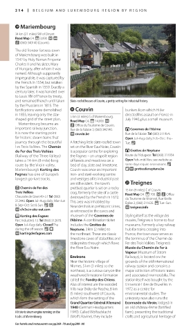
A historic steam engine running on the 1940). Called Wolfsschlucht farm), presenting the traditional
tracks at Mariembourg (Wolf’s Ravine), they include crafts and agricultural heritage of
For hotels and restaurants see pp269–70 and pp289–90
214-215_EW_Belgium.indd 214 18/10/16 3:02 pm
Eyewitness Travel LAYERS PRINTED:
Catalogue template “UK” LAYER
(Source v2.7)
Date 1st October 2013
Size 125mm x 217mm