
Page 229 - (DK Eyewitness) Travel Guide - Belgium & Luxembourg
P. 229
EASTERN W ALL ONIA 227
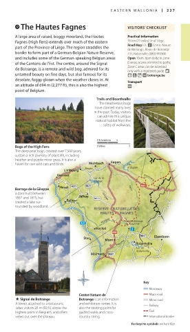
w The Hautes Fagnes VISITORS’ CHECKLIST
A large area of raised, boggy moorland, the Hautes Practical Information
Fagnes (High Fens) extends over much of the eastern 35 km (22 miles) SE of Liège.
part of the Province of Liège. The region straddles the Road Map F3. n Centre Nature
de Botrange, Route de Botrange
border to form part of a German-Belgian Nature Reserve, 131, Robertville; (080) 440300.
and includes some of the German-speaking Belgian areas Open 10am–6pm daily; in Zone
of the Cantons de l’Est. The centre, around the Signal B areas, access is limited to paths;
de Botrange, is a remote and wild bog, admired for its Zone C areas can be accessed
only with a registered guide. 8
untamed beauty on fine days, but also famous for its 9 7 = ∑ botrange.be
desolate, foggy gloom when the weather closes in. At Transport
an altitude of 694 m (2,277 ft), this is also the highest @
point of Belgium.
Trails and Boardwalks
The treacherous bogs
have claimed many lives
in the past. Today, visitors
can admire this unique
natural habitat from the
safety of walkways.
0 kilometres 5
Bogs of the High Fens 0 miles 5
The deep peat bogs, created over 7,500 years,
sustain a rich diversity of plant life, including
heather and purple moor grass. It is also a
haven for rare wild cats and birds. Membach Eupen Lac
Vesdre d’ Eupen
Limbourg
Verviers
Lac de la Getzvach
Gileppe
Barrage de la Gileppe, Heust Helle
a dam built between
1867 and 1875, has Polleur Jalhay Gileppe
created a lake sur-
rounded by woodland.
RESERVE NATURELLE DES
HAUTES FAGNES
Hoégne Signal de Botrange
694 m (2,277 ft)
Hockai
Ster Elsenborn
Mont
Warcher Robertville
Lac de
Robertville
Malmedy
Key
Motorway
Centre Nature de Major road
. Signal de Botrange Botrange is an information Minor road
A tower, attached to a restaurant, and exhibition centre. It is Railway
takes visitors 28 m (92 ft) above the also the starting point for
highest point in Belgium, and offers guided walks and cross- Trail
views out over the plateau. country skiing. International border
For keys to symbols see back flap
226-227_EW_Belgium.indd 227 18/10/16 3:02 pm