
Page 235 - (DK Eyewitness) Travel Guide - Belgium & Luxembourg
P. 235
EASTERN W ALL ONIA 233
Tips for Drivers
9 Dohan Starting point: Jambon de la
The road crosses the Semois on the N935 is accessed
river at Dohan, then pro from the A4E411 Namur–Arlon
vides a series of nota ble motorway; from Exit 23, take the
viewpoints. The first of N835, then the N952.
these is near the riverside Length: About 80 km (50 miles).
rocks of the Rocher de Duration of drive: Allow at least
Dampiry. Beyond it, the a whole day; better to break the
next point lies where the journey into two days.
river performs a series of Driving conditions: Roads are
hairpin bends.
small and winding, but wide
enough for comfortable driving.
Where to stay and eat: There
are restaurants, cafés and
accommodation in villages and
towns all along the way. Bouillon
is the main centre. Many of the
viewpoints have picnic tables.
Visitors’ Information: Vressesur
Semois: Rue Albert Raty 83, (061)
292827; Bouillon: Quai des Saulx
12 and at the châteaufort, (061)
464202 ∑ bouillon-initiative.
be; Florenville: Place Albert 1er,
(061) 311229 ∑ semois-
tourisme.be
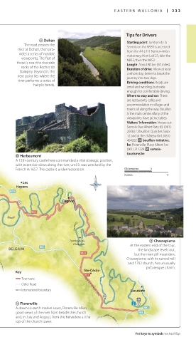
0 Herbeumont
A 13thcentury castle here commanded a vital strategic position,
with extensive views along the river, until it was wrecked by the
French in 1657. The castle is under restoration. 0 kilometres 3
0 miles 3
Les
Hayons
Cugnon
Semois
Semois
Tombeau du q Chassepierre
Chevalier At the eastern end of the tour,
BELGIUM the landscape levels out,
but the river still meanders.
Chassepierre, with its ruined mill
and 1702 church, has unusually
pictur esque charm.
Ste-Cécile
Key
Tour route
Other Road RUE DE BOUILLON
International boundary Lacuisine
w Florenville
A downtoearth market town, Florenville offers
good views of the river from beside the church
and, in July and August, from the belvedere at the
top of the church tower.
For keys to symbols see back flap
232-233_EW_Belgium.indd 233 18/10/16 3:02 pm