Page 18 - Inventions - A Visual Encyclopedia (DK - Smithsonian)
P. 18

Sailing the seas


          People first started traveling by water more than 10,000 years ago. To begin
          with, their boats were simple canoes and rafts propelled with oars or poles.

          Over time, vessels became bigger and more complicated, fitted with sails of
          fabric or animal skin to capture the power of the wind. This made longer
      EARLY BREAKTHROUGHS  they were and in which direction they were heading.       At the top, a
          voyages possible, so people had to invent devices that told them where
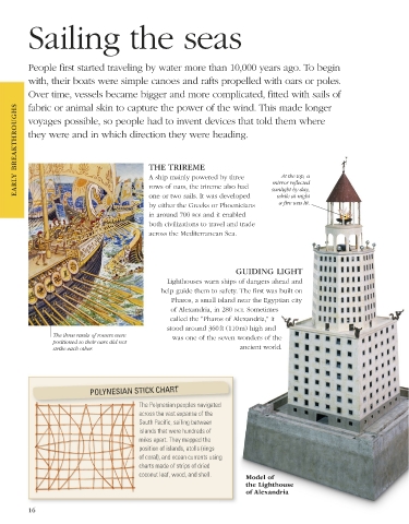


                                              THE TRIREME
                                              A ship mainly powered by three
                                                                                   mirror reflected
                                              rows of oars, the trireme also had
                                              one or two sails. It was developed
                                                                                    while at night
                                                                                     a fire was lit.
                                              by either the Greeks or Phoenicians    sunlight by day,
                                              in around 700 bce and it enabled
                                              both civilizations to travel and trade
                                              across the Mediterranean Sea.


                                                                        GUIDING LIGHT
                                                   Lighthouses warn ships of dangers ahead and
                                                 help guide them to safety. The first was built on
                                                    Pharos, a small island near the Egyptian city
                                                    of Alexandria, in 280 bce. Sometimes
                                                    called the “Pharos of Alexandria,” it
                                                   stood around 360 ft (110 m) high and
                 The three ranks of rowers were      was one of the seven wonders of the
                 positioned so their oars did not
                 strike each other.                                      ancient world.


                            POLYNESIAN STICK CHART

                                           The Polynesian peoples navigated
                                           across the vast expanse of the
                                           South Pacific, sailing between
                                           islands that were hundreds of
                                           miles apart. They mapped the
                                           position of islands, atolls (rings
                                           of coral), and ocean currents using
                                           charts made of strips of dried
                                           coconut leaf, wood, and shell.  Model of
                                                                           the Lighthouse
                                                                           of Alexandria

          16


   US_016-017_Sailing_the_seas_Main.indd   16                                                                    08/03/18   3:09 PM
   13   14   15   16   17   18   19   20   21   22   23