
Page 274 - (DK Eyewitness) Travel Guide - Pacific Northwest
P. 274
272 P A CIFIC NOR THWEST REGION B Y REGION
the original fort, within the
Fort George Park. It contains
a small collection of artifacts
from First Nations cultures,
European pioneers, and early
settlers of the region.
An important center for the
lumber industry, the town of
Prince George offers a range
of free tours of local pulp mills,
which take visitors through the
process of wood production,
from vast fields of young
seedlings to hill-sized piles
of planks and raw timber.
E Exploration Place
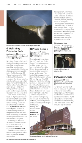
Helmcken Falls, crowned by a rainbow, in Wells Gray Provincial Park 333 Becott Pl. Tel (250) 562-1612.
p Wells Gray a Prince George Open 9am–5pm daily. Closed Jan 1,
Dec 25 & 26. & - = 7
Provincial Park ∑ theexplorationplace.com
Road map 2 B3. * 72,000.
Road map 2 B4. n 416 Eden Rd, n 1300 First Ave, (250) 562-3700.
Clearwater, (250) 674-2646. Open call ∑ tourismpg.com
for hours. ∑ wellsgray.ca
The traditional home of the
Wells Gray Provincial Park, in the Lheidli T’enneh and Carrier
Cariboo Mountains, is not only Sekani First Nations people,
one of the largest but also and the largest town in
one of the most beautiful northern British Columbia,
wildernesses in British Columbia, Prince George is a bustling Dinosaur models on display at
offering wonders comparable supply-and-transportation Exploration Place
to the Rockies in eastern BC. center for the region. Two
The park, established in 1939, major highways pass through
is distinguished by alpine here: the Yellowhead (Highway s Dawson Creek
meadows, thundering waterfalls, 16) and Highway 97, which Road map 2 B3. * 11,000.
and glacier-topped peaks that becomes the Alaska Highway n 900 Alaska Ave, (250) 782-9595.
rise as high as 8,450 ft (2,575 m). at Dawson Creek. Established ∑ tourismdawsoncreek.com
The Canadian National Railroad in 1807 as Fort George, a fur-
and Highway 5 follow the trading post at the confluence The formerly quiet town of
Thompson River along the of the Nechako and Fraser Dawson Creek was transformed
park’s western edge, and both Rivers, the town is well placed by the construction of the
routes provide stunning views. for exploring the province. Alaska Highway, which began
From the Clearwater Valley Prince George has all in 1942 and swelled the town’s
Road, off Highway 5, there are the facilities of a larger city, population from 600 to 10,000.
several trails, from easy walks including its own symphony Designated as historic Mile
to arduous overnight hikes in orchestra, several art galleries, Zero on the road to Fairbanks,
remote country. A short trail and a university specializing in 1,486 miles (2,391 km) to the
leads to spectacular 450-ft First Nations, north, the city recognizes
(137-m) Helmcken Falls, the forestry, and
fourth-highest waterfall in environmental
Canada. Nearby Mushbowl studies.
Bridge provides the best view Exploration
of the fast-moving Murtle River Place lies on
and the giant holes it has carved the site of
into the surrounding rock.
In late August and early
September, Chinook salmon
leap in futile attempts to
continue upstream past
the dramatic Bailey’s Chute.
Four lakes located through-
out the park provide excellent
opportunities for canoeing
and angling. Former grain elevator turned art gallery in Dawson Creek
For hotels and restaurants see pp290–91 and pp304–5
US_PNW_272-273_Catalog4.indd 272 04/07/16 12:35 pm