
Page 276 - (DK Eyewitness) Travel Guide - Pacific Northwest
P. 276
274 P A CIFIC NOR THWEST REGION B Y REGION
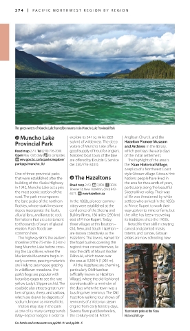
The green waters of Muncho Lake framed by mountains in Muncho Lake Provincial Park
g Muncho Lake explore its 341 sq miles (883 Anglican Church, and the
Provincial Park sq km) of wilderness. The deep Hazelton Pioneer Museum
waters of Muncho Lake offer a
and Archives in the library,
Road map 2 A1. Tel (250) 776-7000. good supply of trout for anglers. which portrays the early days
Open May–Oct: daily. & to campsites. Narrated boat tours of the lake of the initial settlement.
∑ env.gov.bc.ca/bcparks/explore/ are offered by Double G Service The highlight of the area is
parkpgs/muncho_lk/ (tel 250/776-3411). the ‘Ksan Historical Village,
a replica of a Northwest Coast-
One of three provincial parks style Gitxsan village. Gitxsan First
that were established after the h The Hazeltons Nations people have lived in
building of the Alaska Highway Road map 2 A3. * 7,000. n 3026 the area for thousands of years,
in 1942, Muncho Lake occupies Bowser St, New Hazelton, (250) 842- particularly along the beautiful
the most scenic section of the 6571. ∑ newhazelton.ca Skeena River valley. Their way
road. The park encompasses of life was threatened by white
the bare peaks of the northern In the 1860s, pioneer commu- settlers who arrived in the 1850s
Rockies, whose stark limestone nities were established at the at Prince Rupert to work their
slopes incorporate the faults, confluence of the Skeena and way upriver to mine or farm, but
alluvial fans, and fantastic rock Bulkley Rivers, 180 miles (290 km) the tribe has been recovering
formations that are a testament east of Prince Rupert. Today, its traditions since the 1950s.
to thousands of years of glacial three villages at this location – Noted for their skill in creating
erosion. Flash floods are Old, New, and South Hazelton – carved and painted masks,
common here. are known coll e c tively as the totems, and canoes, Gitxsan
The highway skirts the eastern Hazeltons. The towns, named for elders are now schooling new
shoreline of the 7.5-mile- (12-km-) the hazel bushes covering the
long Muncho Lake before cross- region’s river-carved terraces, lie
ing the Liard River, where the near the cliffs of Mount Rocher
Mackenzie Mountains begin. In Déboulé, which tower over
early summer, passing motorists the area at 3,300 ft (1,005 m).
are likely to see moose grazing All the Hazeltons are charming,
in wildflower meadows. The particularly Old Hazelton
park’s bogs are popular with (officially known as Hazelton
botanists eager to see the rare Village), where the old-fashioned
yellow Lady’s Slipper orchid. The storefronts offer a reminder of
roadside also attracts great num- the days when the town was a
bers of goats, sheep, and caribou, bustling river terminus. The Old
which are drawn by deposits of Hazelton walking tour shows off
sodium, known as mineral licks. remnants of a Victorian steam
Visitors may stay in the park engine from early forestry days,
at one of its many campgrounds Skeena River paddlewheelers, ‘Ksan totem poles at the ‘Ksan
(May–Sep) or lodges in order to the century-old St. Peter’s Historical Village
For hotels and restaurants see pp290–91 and pp304–5
US_PNW_274-275_Catalog5.indd 274 04/07/16 12:35 pm