
Page 276 - The Rough Guide to Panama (Travel Guide)
P. 276
274 The Darién anD easTern Panama
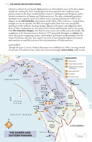
referred to collectively as Chocós). Guna presence is still recalled in some of the place names,
notably the snaking Río Tuira, and though most Guna moved to the Caribbean coast,
pockets remain in the more recently formed comarcas of Madugandi and Wargandi, and in
isolated communities in Panama and Darién provinces. The other substantial population,
dominant in the regional capital of La Palma and in settlements lining the Golfo de San
Miguel, are the Afro-Darienites, descendants on the whole of the cimarrones – escaped slaves
brought over by the Spanish, who fled and waged warfare from their own strongholds
(palenques) in the rainforest, forming strategic alliances with pirates and indigenous tribes.
Some of their communities are now mixed with Emberá and Wounaan, and, in some parts,
with Afro-Colombian refugees, who fled the more recent civil conflict across the border. The
completion of the Interamericana to Yaviza in 1979 opened the floodgates to colonos (the
name often given to migrating mestizo cattle ranchers and farmers predominantly from the
Azuero Peninsula), who have now cleared vast tracts of land along the highway for pasture,
and constitute around fifty percent of the total population of Darién province.
Local conflicts
Though the joint Comarca Emberá-Wounaan was established in 1983, covering around
25 percent of Darién province, there have been increasingly violent clashes with mestizo
Cartí hiGhLiGhTs
CARIBBEAN
SEA Lago Bayano
Akua
El Llano Guna Icantí Parque Nacional Darién
Chepo Cañita Lago Archipiélago de Guna Yala (San Blas ) Staying with the Emberá
Bayano
RÍo Chepo Ipetí or Wounaan
Cuevas Agua Fría GUNA YALA Harpy eagle nests
Isla de majé N°1 Río Sambú
Chepillo PANAMÁ Tortí The Pacific coast
Agua Fría
Golfo de Panamá N°2 Puerto
SERR ANÍA Obaldía
DE MA JÉ
Capurganá
Santa Fé S E R R A N Í A D E L D A R I É N
I N TERA M E R I C AN A
Puerto Lara Río Chucunaque
(Boca Lara) Metetí
Puerto Quimba RESERVA Golfo de Urabá
Isla La Palma HIDROLÓGICA
del Punta FILO DEL TALLO PARQUE
Isla Rey Golfo de Alegre RESERVA FORESTAL NACIONAL
DEL CANGLÓN
San San Miguel Chepigana DARIÉN
José Punta Patiño Mogué
A rchipiélago La Marea Yaviza
Río Mogué
de la s Perla s Taimati Unión Chocó
La Chunga El Real Cerro
Garachiné Puerto Indio/ DARIÉN Boca de Cupe Tacarcuna
(1874m)
rancho Frío
Cerro Sapo Sambú (Pirre station)
(1145m) Paya
Playa Muerto Cerro Pirre
(1200m)
P A CIFIC OCEAN Río Sambú Río Balsas Santa Cruz
de Cana Río Tuira
N S E R R A N Í A D E L S A P O SE RR A N ÍA D E JU N G URU DÓ
Pavarandó
PARQUE
NACIONAL COLOMBIA
DARIÉN
The Darién anD Bahía Piñas Puerto Piñas
easTern Panama Jaqué Río Jaqué 0 kilometres 25
270-289_Panama_3_Ch8.indd 274 30/06/17 11:52 am