
Page 96 - (DK Eyewitness) Travel Guide - Italian Riviera
P. 96
94 GENO A AREA B Y AREA
GENOA STREET FINDER
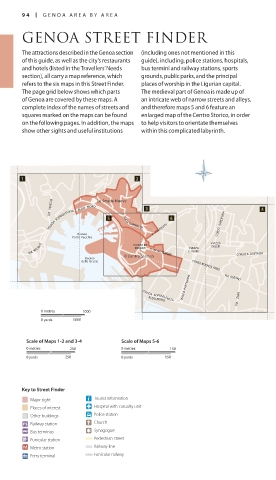
The attractions described in the Genoa section (including ones not mentioned in this
of this guide, as well as the city’s restaurants guide), including, police stations, hospitals,
and hotels (listed in the Travellers’ Needs bus termini and railway stations, sports
section), all carry a map reference, which grounds, public parks, and the principal
refers to the six maps in this Street Finder. places of worship in the Ligurian capital.
The page grid below shows which parts The medieval part of Genoa is made up of
of Genoa are covered by these maps. A an intricate web of narrow streets and alleys,
complete index of the names of streets and and therefore maps 5 and 6 feature an
squares marked on the maps can be found enlarged map of the Centro Storico, in order
on the following pages. In addition, the maps to help visitors to orientate themselves
show other sights and useful institutions within this complicated labyrinth.
VIA VENEZIA
STRADA SOPRAELEVATA ALDO MORO Le Strade Nuove VIA G. GARIBALDI CORSO SARDEGNA
Bacino V. ASSAROTTI
Porto Vecchio
VIA MILANO PIAZZA DE V. XX SETTEMBRE G. VERDI PIAZZA CORSO A. GASTALDI
GIUSTI
FERRARI
PIAZZA
Bacino Il Centro Storico
delle Grazie CORSO BUENOS AIRES
VIALE B. PARTIGIANE VIA ALBARO
STRADA SOPRAELEVATA
0 metres 1000 ALDO MORO VIA ZARA
0 yards 1000
Scale of Maps 1-2 and 3-4 Scale of Maps 5-6
0 metres 250 0 metres 150
0 yards 250 0 yards 150
Key to Street Finder
Major sight Tourist information
Places of interest Hospital with casualty unit
Other buildings Police station
Railway station Church
Bus terminus Synagogue
Funicular station Pedestrian street
Metro station Railway line
Ferry terminal Funicular railway
094-097_EW_Italian_Riviera.indd 94 09/09/16 10:47 am