
Page 16 - (DK Eyewitness) Travel Guide - New Orleans
P. 16
14 INTRODUCING NE W ORLEANS
Covington
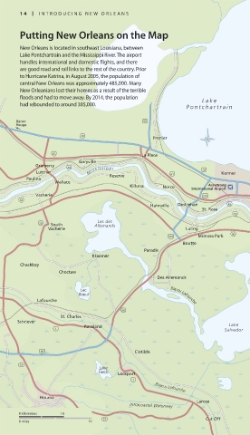
Putting New Orleans on the Map
New Orleans is located in southeast Louisiana, between
Lake Pontchartrain and the Mississippi River. The airport
handles international and domestic flights, and there
are good road and rail links to the rest of the country. Prior
to Hurricane Katrina, in August 2005, the population of
central New Orleans was approximately 485,000. Many
New Orleanians lost their homes as a result of the terrible
floods and had to move away. By 2014, the population Lake
had rebounded to around 385,000. Pontchartrain
Baton 55
Pontchartrain Causeway
Rouge
10 Frenier
61 La Place
Garyville
Gramercy Lakefront
44 Airport 90
Lutcher M i s s i s s i p p i 61 10 Kenner
Paulina Reserve 47
Wallace 90
Killona Norco International Airport
Armstrong
Vacherie 310 Metairie 61 Lake
18 River Borgne
Hahnville Destrehan 48 Ridge
St. Rose Chalmette
18 New Algiers
Harahan
Lac des Orleans M ississippi Meraux
20 South Allemands 90
Vacherie Luling Avondale Gretna 39
310 Mimosa Park 90 Marrero Harvey Terrytown 46
Boutte Westwego 23 Poydras
Paradis Belle St. Bernard 46
Kraemer Estelle Chasse 39
Chackbay Lake Reggio
Cataouatche
Choctaw
Des Allemands Couba Dalcour
Island Lake Lery
Lac
Boeuf Bayou Lafourche Bertrandville
Lafourche Willis
Crown Point Delacroix
Point Jesuit
90 Bend
St. Charles Lake
Schriever Barataria Belair Petit
Raceland Lake Naomi 39
1 Salvador
Lafitte
Carlisle
23
90 Clotilda Phoenix
Ironton
Davant
24 Lake Myrtle
Fields Lockport Grove
1 Bayou Lafourche
Lake Magnolia
M ississippi
Houma Laurier Bohemia
Larose
Intracoastal Waterway
Diamond
0 kilometers 10
24 Cut Off
0 miles 10
014-015_EW_New_Orl.indd 14 05/08/16 3:48 pm
Eyewitness Travel LAYERS PRINTED:
Orientations template “UK” LAYER
(Source v1.3)
Date 6th November 2012
Size 125mm x 217mm