
Page 194 - (DK Eyewitness) Travel Guide - India
P. 194
192 CENTR AL INDIA
Trekking in Garhwal and Kumaon
No Himalayan ranges are as rich in myth and legend as
those of Garhwal and Kumaon (Uttarakhand’s eastern Garhwal
hills). The area is known as Dev Bhoomi (“Abode of the Kumaon
Gods”), and every peak, river and trail is either named after UTTARAKHAND
a Hindu god or goddess, or finds mention in holy scriptures.
Relatively easy to access, Garhwal and Kumaon are a
wonderful introduction to the Himalayas. A single walk can UTTAR PRADESH
lead through forests, valleys bursting with wild flowers, and
glacial moonscapes of rock and ice. The best seasons are
between February and May, and September and November. Locator Map
Areas shown below
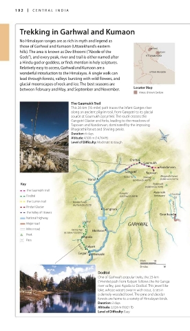
The Gaumukh Trail
This 26-km (16-mile) path traces the infant Ganges river
along an ancient pilgrim trail, from Gangotri to its glacial
source at Gaumukh (see p166). The route crosses the
Gangotri Glacier and forks, leading to the meadows of
Tapovan and Nandanvan, dominated by the imposing
Bhagirathi Parvat and Shivling peaks. Valley of
Duration: 6 days Flowers
Altitude: 4,500 m (14,764 ft) Ghangaria
Level of Difficulty: Moderate to tough Hemkund
Nanda Devi East
•Bhiundhar (7,430 m/24,377 ft)
Jahnavi Chirbas Gaumukh Govindghat Rishi G anga (7,817 m/25,646 ft)
Nanda Devi
Glacier
Nandanvan Joshimath Nanda Devi Pindari
Bhagirathi Gangotri Tapovan Auli Tapovan
Sanctuary
Bhagirathi Parvat
Shivling
Harsil Kedar Tal (6,540 m/21,457 ft) (6,860 m/22,507 ft) Phurkiya
Key Kedarnath Trishul Dwali
(6,940 m/22,769 ft) Alaknanda Kuari Pass (7,120 m/23,360 ft)
The Gaumukh Trail (4,268 m/ Pana Sundardhunga
Gangotri Kedarnath Chorabari 14,003 ft)
Dodital (6,670 m/21,883 ft) Sanctuary Tal Pipalkoti Jhinji KUMAON
The Curzon Trail Bandar Punch Khati
(6,316 m/20,722 ft) Gohna Chechni Binayak
Pindari Glacier Mandakini Tal Pass Loharkhet
Gangnani Dhakuri
The Valley of Flowers Ramni
Gaurikund
National highway Chamoli Karmi
Dodital Song
Major road GARHWAL Nandprayag Ghat Pindar
Minor road Darwa Top Bhatwari Bekhal
Tal
Peak (4,130 m/13,550 ft)
Agoda
Pass
Kalyani
Asi Ganga
Gegari Uttarkashi
0 km 10
0 miles 10
Dodital
One of Garhwal’s popular treks, the 23-km
(14-mile) path from Kalyani follows the Asi Ganga
river valley, past Agoda to Dodital. This jewel-like
lake, whose waters swarm with trout, is set in
a densely wooded bowl. The pine and deodar
forests are home to a variety of Himalayan birds.
Duration: 3 days
Altitude: 3,024 m (9,921 ft)
Level of Difficulty: Easy
192-193_EW_India.indd 192 26/04/17 11:44 am
Eyewitness Travel LAYERS PRINTED:
Feature template “UK” LAYER
(SourceReport v1.3)
Date 18th October 2012
Size 125mm x 217mm