
Page 193 - (DK Eyewitness) Travel Guide - India
P. 193
UT T AR PR ADESH & UT T AR AKHAND 191
q The Garhwal Hills
Uttarkashi and Chamoli districts.
148 km (92 miles) NE of Rishikesh
to Uttarkashi. @ TGMA Bus Station,
(01374) 222 154. n Uttarakhand
Tourist Bureau, Uttarkashi, (01374)
223 573/130. ∑ uttarkashi.nic.in
The northern stretches of
Garhwal (Uttarakhand’s western
hills) are strewn with pilgrim
towns, ancient shrines and
forbidding snowbound peaks.
Uttarkashi, the main town,
lies 148 km (92 miles) north of
Rishikesh (see p188), and is an
important starting point for Badrinath, Garhwal’s foremost dham (holy abode) and source of the Alaknanda river
treks to the upper reaches of
Garhwal. A leading school for from Uttarkashi, Haridwar head at Gaurikund. The most
aspiring climbers, the Nehru and Rishikesh. visited of all the Char Dham
Institute of Mountaineering, Yamunotri, 209 km (130 miles) shrines, Badrinath is situated
is situated in this town, and north of Rishikesh, is the source 298 km (185 miles) northeast of
boasts of having trained of the Yamuna, and a 13-km Rishikesh. Its colourfully
Bachendri Pal, the first Indian (8-mile) walk from painted temple,
woman to scale Mount Hanuman Chatti. Its dedicated to Vishnu,
Everest in 1984. temple was rebuilt is usually packed with
This region also encompasses in the 20th century pilgrims. The town
an area traditionally known as after the earlier one has a specta cular
Dev Bhoomi (“Abode of the was destroyed by setting, wedged
Gods”). The Char Dham, or four floods. The small between the Nar
major places of pilgrimage, village of Gangotri, and Narayan ranges.
Gangotri, Yamunotri, Kedarnath named after the The Neelkanth, or
and Badrinath, are all situated Ganges, which flows “Blue Throat Peak”,
here at altitudes over 3,100 m through it, lies 100 A mendicant in named after Lord
(10,171 ft), in the shadow of some km (62 miles) northeast saffron robes Shiva, towers over
awe-inspiring Himalayan peaks. of Uttarkashi. Its 18th- Badrinath at a
The pilgrimage season lasts cen tury temple has images of height of 6,957 m (22,825 ft).
from April to early November, Hindu deities. Gaumukh, the Joshimath, lying 250 km
after which the snows drive source of River Ganges, lies 18 km (155 miles) northeast of Rishikesh
away all but the most devout. (11 miles) upstream, below the at the confluence of the Dhauli
All four sites can be reached soaring Bhagirathi peaks, and Ganga and Alak nanda rivers
can be reached via at Vishnuprayag, is one of the
a path that follows four mathas (seats of learning)
the lovely river valley. established by the great 9th-
At this point, the century sage, Adi Shankaracharya
river is known as the (see p652). It is also the junction
Bhagirathi, and only of two ancient trans-Himalayan
becomes the Ganges trading routes. The town was a
proper after it joins gateway to the Nanda Devi
the Alaknanda river at Sanctuary (see p193), until the
Devprayag (see p166). sanctuary was closed to the public
The impressive in 1983. Today, visitors head mostly
Kedarnath peaks for the ski slopes of Auli, reached
form the backdrop via road or cable car from
for the pilgrim town Joshimath. The trek to the Sikh
of Kedarnath, sacred shrine of Hemkund Sahib and
to Shiva, and 223 km the Valley of Flowers National
(139 miles) northeast Park (see p193) begins 20 km
of Rishikesh. A (12 miles) north of Joshimath,
beautifully carved from Ghangaria. The Valley of
stone temple, said Flowers, best visited between the
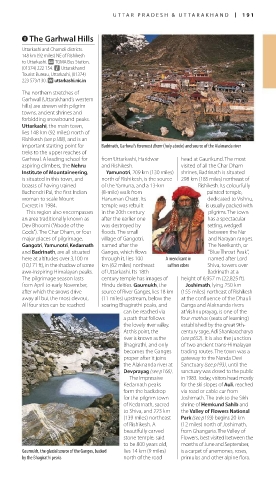
to be 800 years old, months of June and September,
Gaumukh, the glacial source of the Ganges, backed lies 14 km (9 miles) is a carpet of anemones, roses,
by the Bhagirathi peaks north of the road primulas and other alpine flora.
190-191_EW_India.indd 191 26/04/17 11:44 am