
Page 332 - (DK Eyewitness) Travel Guide - India
P. 332
330 EASTERN INDIA
sculptures and an Tezpur, is often described as a
exquisitely carved mini-Kaziranga (see pp334–5),
door frame, with images since it has a similar landscape
of the river goddesses of marshes, streams and
Ganga and Yamuna on grassland, the favoured habitat
either side. Chitralekha of the one-horned rhinoceros.
Udyan, close to the This little sanctuary is also
Tourist Lodge, is Tezpur’s home to the Asiatic wild buffalo
prettiest spot, with a and the Hoolock gibbon.
beautifully landscaped
garden near a lake. O Nameri Sanctuary
It is embellished with Permits: Divisional Forest Officer,
9th- and 10th-century Western Assam Wildlife Division,
sculptures unearthed Dolabari, Tezpur, (03712) 268 054
in the city. A charming Open Nov–Apr. & Extra charges for
19th-century colonial photography. 8 Potasali Eco-
church stands behind Camp (09435) 145 563, (09435) 250 025.
the Tourist Lodge. O Orang Wildlife Sanctuary
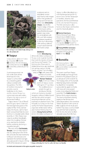
Ruins of Tezpur’s Da Parbatia Temple, dating to the Permits Divisional Forest Officer,
5th–6th centuries AD Environs Mangaldoi, (03713) 230 022.
Scenic Bhalukpong, Open Oct–Apr. & 8
2 Tezpur 58 km (36 miles) northwest of
Tezpur, is set in green foothills
Sonitpur district. 180 km (112 miles) 3 Bomdila
NE of Guwahati. * 102,500. that mark the border of Assam
~ Salonibari, 10 km (6 miles) N of and Arunachal Pradesh. The West Kameng district. 140 km
town centre, then bus or taxi. £ @ Kameng river flows past it. (87 miles) NW of Tezpur. @
n Tourist Office, Zenkins Rd, (03712) Added attractions are medicinal _ Losar (Feb/Mar). Travel permits:
221 016. hot springs, and an Orchid required (see p734).
Centre, located 7 km (4 miles)
A picturesque town on away at Tipi, with some 500 The scenic road from Tezpur
the north bank of the varieties of orchids winds steeply up through thick
Brahmaputra river, native to Arunachal. forests to this pleasant town, at
Tezpur is surrounded Nameri National an altitude of 2,530 m (8,301 ft).
by undulating green Park, 35 km (22 miles) The headquarters of Arunachal’s
valleys covered with north of Tezpur, covers West Kameng district, Bomdila
tea gardens. The hills 200 sq km (77 sq miles). has Buddhist monasteries
of northern Arunachal The Jia Bhoroli river surrounded by apple orchards,
provide a scenic Epiphytic orchid winds through its with views of snowcapped
backdrop to the town, deciduous forests, peaks, terraced paddy fields and
and for visitors, Tezpur is a which are home to clouded waterfalls. The Crafts Centre is
convenient stop and a take- leopards, mithuns (Indian bison) famous for its carpet weaving.
off point for trips to parts of and the rare white-winged The town’s inhabitants belong
Arunachal Pradesh. wood duck. Nameri can be largely to the Monpa and
Tezpur means “City of Blood”, explored on elephant back. The Sherdukpen tribes, who combine
and this gory name is derived Potasali Eco-Camp on the river, Tibetan Buddhism with some of
from its legendary past as the run by the Forest Department, their original animist rituals and
capital of the Hindu demon organizes white-water rafting beliefs. They wear a curious black
kings, the Asuras, said to have and mahseer fishing trips for cap with five “tails” projecting
been vanquished here by Lord visitors. Orang National Park, from its rim, that serve to drain
Krishna in a bloody battle. More 65 km (40 miles) northwest of rainwater away from the face.
recently, in 1962, Tezpur was
close to another bloodbath,
when the invading Chinese
army reached its outskirts
before suddenly declaring a
ceasefire (see p61).
The ruins of the Da Parbatia
Temple, 5 km (3 miles) west of
the city, dating from the 5th to
6th centuries AD, bear testimony
to Tezpur’s ancient past, and
represent the earliest example
of sculptural art in Assam. All that
is left of the temple are some Monpas celebrating their New Year with a Yak Dance near Bomdila
For hotels and restaurants in this region see pp698–9 and p712
330-331_EW_India.indd 330 26/04/17 11:45 am
Eyewitness Travel LAYERS PRINTED:
Catalogue template “UK” LAYER
(Source v2.6)
Date 12th July 2013
Size 125mm x 217mm