
Page 341 - (DK Eyewitness) Travel Guide - India
P. 341
ASSA M & THE NOR THEAST 339
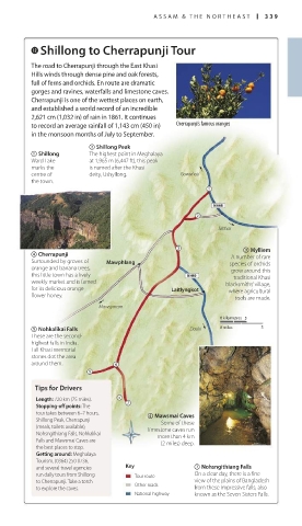
w Shillong to Cherrapunji Tour
The road to Cherrapunji through the East Khasi
Hills winds through dense pine and oak forests,
full of ferns and orchids. En route are dramatic
gorges and ravines, waterfalls and limestone caves.
Cherrapunji is one of the wettest places on earth,
and established a world record of an incredible
2,621 cm (1,032 in) of rain in 1861. It continues
to record an average rainfall of 1,143 cm (450 in) Cherrapunji’s famous oranges
in the monsoon months of July to September.
2 Shillong Peak
1 Shillong The highest point in Meghalaya
Ward Lake at 1,965 m (6,447 ft), this peak
marks the is named after the Khasi
centre of deity, Ushyllong. Guwahati
the town.
Silchar
3 Mylliem
4 Cherrapunji A number of rare
Surrounded by groves of Mawphlang species of orchids
orange and banana trees, grow around this
this little town has a lively traditional Khasi
weekly market and is famed blacksmiths’ village,
for its delicious orange- Laitlyngkot where agricultural
flower honey. tools are made.
Mawsynram
0 kilometres 5
5 Nohkalikai Falls Dauki 0 miles 5
These are the second-
highest falls in India.
Tall Khasi memorial
stones dot the area
around them.
Tips for Drivers
Length: 120 km (75 miles).
Stopping-off points: The
tour takes between 6–7 hours. 6 Mawsmai Caves
Shillong Peak, Cherrapunji Some of these
(meals, toilets available), limestone caves run
Nohsngithiang Falls, Nohkalikai more than 4 km
Falls and Mawsmai Caves are (2 miles) deep.
the best places to stop.
Getting around: Meghalaya
Tourism, (0364) 250 0736,
and several travel agencies Key 7 Nohsngithiang Falls
run daily tours from Shillong Tour route On a clear day, there is a fine
to Cherrapunji. Take a torch Other roads view of the plains of Bangladesh
to explore the caves. from these impressive falls, also
National highway known as the Seven Sisters Falls.
338-339_EW_India.indd 339 26/04/17 11:46 am