
Page 471 - (DK Eyewitness) Travel Guide - India
P. 471
SOUTHWESTERN INDIA 469
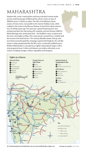
MAHARASHTRA
Verdant hills, scenic coastal plains and busy industrial centres make
up the varied landscape of Maharashtra, which covers an area of
308,000 sq km (118,920 sq miles). The hills of the Western Ghats,
source of many rivers, run parallel to the narrow Konkan Coast, while
cradled in the centre is the Deccan Plateau, formed from black volcanic
lava 70 million years ago. This area saw a great flowering of art and
architecture from the 2nd century BC onwards, and two famous UNESCO
World Heritage sites are located here – the Buddhist caves at Ajanta and
the rock-cut temples at Ellora. The rocky terrain around Pune is dotted with
the massive forts built by the 17th-century Maratha leader, Shivaji, who
launched successful guerrilla campaigns against the Mughals. His cult-like
status is today perpetuated by the Shiv Sena, a nationalist political party.
Modern Maharashtra is a prosperous, highly industrialized region, with a
strong agrarian base. Cotton and tobacco are widely cultivated, as are
various including oranges, chikoos (sapodilla) and mangoes.
Sights at a Glance
Towns & Cities Temple Towns & National Parks &
4 Kolhapur Holy Places Geographical Sites
6 Pune 0 Nasik t Lonar
9 Ahmadnagar o Pandharpur y Melghat Tiger Reserve
q Aurangabad Historic Sites Hill Stations
u Nagpur
i Wardha 2 Murud-Janjira 5 Mahabaleshwar
w Daulatabad 7 Lonavla
0 kilometres 100 e Ellora 8 Matheran
r Ajanta Beaches
0 miles 50
1 Alibag
3 Ganapatipule
Bharuch Narmada
•
• NH69
Surat Tapti • Ramtek
NH6
• • Amravati
NH3 Dhule •
Silvassa Akola
•
NH8
Shirdi • Godavari
Adilabad •
Mumbai
• NH50 NH222 Nanded • NH44
Panchgani NH211
•
Satara NH9 Key
•
Chiplun • • Solapur National highway
Major road
NH204
• NH13 Minor road
Ratnagiri • NH4
Panhala Krishna Major railway
State border
NH66
Belgaum
•
Mural showing the face of Avalokiteshvara, the most venerated Bodhisattva at Ajanta caves For keys to symbols see back flap
468-469_EW_India.indd 469 26/04/17 11:54 am