
Page 22 - (DK Eyewitness) Travel Guide - Scotland
P. 22
20 INTRODUCING SC O TLAND A POR TR AIT OF SC O TLAND 21
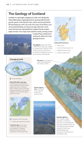
The Geology of Scotland U-shaped valleys in
the Highlands are a
Scotland is a geologist’s playground, with rocks displaying legacy of the last Ice
Age. The weight and
three billion years of geological time. Starting with the hard move ments of glaciers
granitic gneiss in the Western Isles, which was formed before broke off spurs,
life developed on earth, the rocks tell a story of lava flows, eras deepening and
of mountain building, numerous ice ages and even a time rounding out the
existing river valleys.
when the land was separated from England by the ancient
Iapetus Ocean. Four major fault and thrust lines, running across
Scotland from north east to Quartzite peaks soar
southwest, define the main Freshwater loch above a base of sand stone
in parts of the Tor ridon
geological zones. range. The quartzite can
Rock layers in be mistaken for snow from
a stepped effect a distance.
Fault and Thrust Lines
The gabbro (dark rock) of the Moine Thrust The basalt columns of the
Cuillin Hills on Skye was created Isle of Staffa (see p137) were
by subterra nean magma in the Great Glen Fault (see pp152–3) Deep sea loch formed 60 million years ago.
Tertiary period, a time when Highland Boundary Fault A flow of lava cooled slowly,
the dinosaurs had died out and Southern Uplands Fault contracting and fracturing
mammals were flourishing. in a distinctive hexagonal
pattern similar to the Giant’s
Causeway in Ireland.
Changing Earth
The action of sea tides and
waves continually erodes
the existing coastline.
Scotland Equator
•
Iapetus Ocean
England
•
Ancient landmass
About 500 million years ago
Scotland was part of a landmass
that included North America, while
England was part of Gondwana. Plateau-topped
After 75 million years of continen tal hills on the island The Highland
breakup and drift, the two countries are the exposed Boundary Fault runs
“collided”, not far from the modern remains of a from Stonehaven, on
political boundary. basalt lava flow. the east coast, to Arran
on the west as an
obvious line of hills.
Serpentine
Scandinavia
Scotland Old lava flow
Typical Features
This cross-section is an idealized
Lewisian gneiss is representation (not to scale) of some of the
Glaciation in the last Ice Age one of earth’s oldest
substances, created in distinctive geology of the Highlands and
Present-day national boundaries islands of northwest Scotland. The tortuously
the lower crust three billion
The last Ice Age, which ended years ago and later thrust up indented coastline of this part of the country Devonian sandstone is prevalent in the
10,000 years ago, was the most and exposed. Hard, infertile is a result of high precipitation in the area Orkney Islands (see pp162–3). In places,
recent chapter in Scotland’s and grey, it forms low during the last Ice Age which heavily eroded the sea has eroded the horizontally
geological history when, like plateaus filled with the layers of ancient rocks, leaving a layered rock into spectacular cliffs and
Scandinavia, it became glaciated. thousands of small lochs in beautiful and contrasting land scape of stacks, as with the 137-m (450-ft) Old
the Western Isles. boulder-strewn glens and deep lochs. Man of Hoy.
020-021_EW_Scotland.indd 20 10/23/17 11:56 AM 020-021_EW_Scotland.indd 21 10/23/17 11:56 AM