
Page 455 - NEWGEN21-Proceedings-Full
P. 455
Paterson Province – Setting
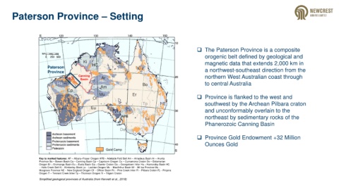
❑ The Paterson Province is a composite
orogenic belt defined by geological and
magnetic data that extends 2,000 km in
Paterson
Province a northwest-southeast direction from the
Canning northern West Australian coast through
Basin
to central Australia
❑ Province is flanked to the west and
southwest by the Archean Pilbara craton
and unconformably overlain to the
northeast by sedimentary rocks of the
Phanerozoic Canning Basin
❑ Province Gold Endowment +32 Million
Ounces Gold
Gold Camp
Key to marked features: AF – Albany–Fraser Orogen AFB – Adelaide Fold Belt Am – Amadeus Basin Ar – Arunta
Province Bo – Bowen Basin Ca – Canning Basin Cp – Capricorn Orogen Cu – Curnamona Craton De – Delamarian
Orogen Er – Eromanga Basin Eu – Eucla Basin Ga – Gawler Craton Ge – Georgetown Inlier Ha – Hamersley Basin HC
– Halls Creek Belt Ki – Kimberley Block La – Lachlan Orogen Mc – MacArthur Basin MI – Mt Isa Province Mu –
Musgrave Province NE – New England Orogen Of – Officer Basin Pc – Pine Creek Inlier Pi – Pilbara Craton Pj – Pinjarra
Orogen T – Tennant Creek Inlier Tp – Thomson Orogen Yi – Yilgarn Craton
Simplified geological provinces of Australia (from Kennett et al., 2018)